Results
| Country: | U.S.A.
| | Station: | WELDON, N. C. | | River: | ROANOKE RIVER | | Area: | 21884.20 | | Lat: | 36.42 | | Lon: | -77.57 | | Source: | USGS | | PointID: | 2080600 | | Area Units: | km2 | | Discharge Units: | m3/sec | | Starting Year: | 1963 | | Ending Year: | 1970 | | Total Years: | 8 | | Total Usable Years: | 4 | |
| |
| Year | Jan | Feb | Mar | Apr | May | Jun | Jul | Aug | Sep | Oct | Nov | Dec | Avg Annual |
|---|
| 1963 | -9999 | -9999 | -9999 | -9999 | -9999 | -9999 | -9999 | -9999 | -9999 | -9999 | -9999 | 0 | -9999 |
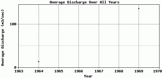
| 1964 | 0 | 0 | 0 | 0 | 0 | 0 | 0 | 0 | 0 | 0 | 0 | 150.32 | 12.53 |
| 1965 | 175.71 | 246.42 | 331.03 | 170.71 | 191.74 | 117.88 | 134.05 | 143.77 | 107.48 | -9999 | -9999 | -9999 | -9999 |
| 1966 | -9999 | -9999 | -9999 | -9999 | -9999 | -9999 | -9999 | -9999 | -9999 | -9999 | -9999 | -9999 | -9999 |
| 1967 | -9999 | -9999 | -9999 | -9999 | -9999 | -9999 | -9999 | -9999 | -9999 | -9999 | -9999 | -9999 | -9999 |
| 1968 | -9999 | 172.12 | 171.6 | 148.26 | 159.12 | 177.33 | 145.13 | 143.47 | 62.71 | 83.82 | -9999 | -9999 | -9999 |
| 1969 | 128 | 185.54 | 135.3 | 114.34 | 176.29 | 124.56 | 131.05 | 122.39 | 102.46 | 164.77 | 125.46 | 131.94 | 136.84 |
| 1970 | 184.53 | 167.27 | 118.58 | 117.35 | 177.1 | 110.26 | 71.52 | 200.69 | 140.12 | -9999 | -9999 | -9999 | -9999 |
| |
|
|
|
|
|
|
|
|
|
|
|
|
|
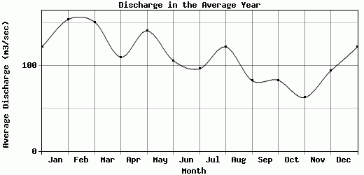
| Avg | 122.06 | 154.27 | 151.3 | 110.13 | 140.85 | 106.01 | 96.35 | 122.06 | 82.55 | 82.86 | 62.73 | 94.09 | 74.69 |
| |
|
|
|
|
|
|
|
|
|
|
|
|
|
| Std Dev | 73.68 |
82.17 |
106.71 |
58.86 |
71.18 |
58.01 |
54.6 |
66.35 |
48.04 |
67.27 |
62.73 |
66.95 |
62.16 |
| |
|
|
|
|
|
|
|
|
|
|
|
|
|
| | Jan | Feb | Mar | Apr | May | Jun | Jul | Aug | Sep | Oct | Nov | Dec | Avg Annual |
Click here for this table in tab-delimited format.
Tab-delimited format will open in most table browsing software, i.e. Excel, etc.
View this station on the map.
Return to start.