Results
| Country: | U.S.A.
| | Station: | MT VERNON AL | | River: | MOBILE RIVER | | Area: | 111363.40 | | Lat: | 31.09 | | Lon: | -87.97 | | Source: | USGS | | PointID: | 2470500 | | Area Units: | km2 | | Discharge Units: | m3/sec | | Starting Year: | 1953 | | Ending Year: | 1955 | | Total Years: | 3 | | Total Usable Years: | 1 | |
| |
| Year | Jan | Feb | Mar | Apr | May | Jun | Jul | Aug | Sep | Oct | Nov | Dec | Avg Annual |
|---|
| 1953 | -9999 | -9999 | -9999 | -9999 | -9999 | -9999 | -9999 | -9999 | -9999 | 438.98 | 381.39 | 1951.75 | -9999 |
| 1954 | 1994.34 | 2091.11 | 1727.7 | 2119.34 | 982.23 | 463.93 | 312.01 | 297.56 | 266.95 | 279 | 294.29 | 305.84 | 927.86 |
| 1955 | 1238 | -9999 | -9999 | -9999 | -9999 | -9999 | -9999 | -9999 | -9999 | -9999 | -9999 | -9999 | -9999 |
| |
|
|
|
|
|
|
|
|
|
|
|
|
|
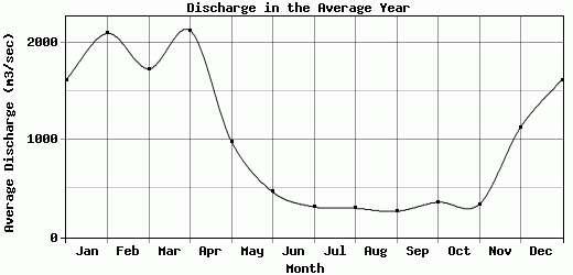
| Avg | 1616.17 | 2091.11 | 1727.7 | 2119.34 | 982.23 | 463.93 | 312.01 | 297.56 | 266.95 | 358.99 | 337.84 | 1128.8 | 927.86 |
| |
|
|
|
|
|
|
|
|
|
|
|
|
|
| Std Dev | 378.17 |
0 |
0 |
0 |
0 |
0 |
0 |
0 |
0 |
79.99 |
43.55 |
822.96 |
0 |
| |
|
|
|
|
|
|
|
|
|
|
|
|
|
| | Jan | Feb | Mar | Apr | May | Jun | Jul | Aug | Sep | Oct | Nov | Dec | Avg Annual |
Click here for this table in tab-delimited format.
Tab-delimited format will open in most table browsing software, i.e. Excel, etc.
View this station on the map.
Return to start.