Results
| Country: | U.S.A.
| | Station: | RIMER, PA. | | River: | ALLEGHENY RIVER | | Area: | 21726.22 | | Lat: | 40.96 | | Lon: | -79.54 | | Source: | USGS | | PointID: | 3033000 | | Area Units: | km2 | | Discharge Units: | m3/sec | | Starting Year: | 1938 | | Ending Year: | 1945 | | Total Years: | 8 | | Total Usable Years: | 7 | |
| |
| Year | Jan | Feb | Mar | Apr | May | Jun | Jul | Aug | Sep | Oct | Nov | Dec | Avg Annual |
|---|
| 1938 | -9999 | -9999 | -9999 | -9999 | -9999 | -9999 | -9999 | -9999 | -9999 | 85.96 | 213.71 | 286.59 | -9999 |
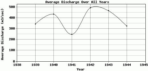
| 1939 | 372.62 | 983.31 | 905.96 | 753.52 | 153.68 | 81.26 | 55.12 | 61.04 | 29.05 | 134.29 | 181.59 | 399.84 | 342.61 |
| 1940 | 173.1 | 327.86 | 642.38 | 1791.14 | 428.53 | 387.19 | 162.1 | 48.27 | 92.76 | 63.44 | 218.44 | 855.97 | 432.6 |
| 1941 | 499.56 | 227.5 | 538.68 | 661.18 | 132.23 | 200.54 | 89.33 | 98.28 | 41.37 | 72.93 | 147.53 | 259.26 | 247.37 |
| 1942 | 293.87 | 480.37 | 1327.07 | 766.43 | 424.84 | 171.55 | 328.76 | 129.7 | 191.75 | 378.81 | 722.56 | 674.31 | 490.84 |
| 1943 | 881.66 | 814.26 | 836.07 | 703.33 | 1108.75 | 497.86 | 121.91 | 105.85 | 44.37 | 82.22 | 228.51 | 146.5 | 464.27 |
| 1944 | 213.42 | 417.62 | 892.44 | 882.83 | 562.41 | 244.37 | 79.67 | 36.05 | 58.06 | 94.41 | 123.41 | 267.02 | 322.64 |
| 1945 | 250.27 | 648.72 | 1846.36 | 750.68 | 607.7 | 385.84 | 191.53 | 111.08 | 228.03 | -9999 | -9999 | -9999 | -9999 |
| |
|
|
|
|
|
|
|
|
|
|
|
|
|
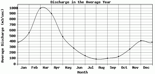
| Avg | 383.5 | 557.09 | 998.42 | 901.3 | 488.31 | 281.23 | 146.92 | 84.32 | 97.91 | 130.29 | 262.25 | 412.78 | 383.39 |
| |
|
|
|
|
|
|
|
|
|
|
|
|
|
| Std Dev | 227.01 |
251.48 |
415.98 |
368.73 |
304.97 |
135.74 |
86.34 |
32.96 |
73.83 |
103.58 |
191.33 |
238.04 |
85.99 |
| |
|
|
|
|
|
|
|
|
|
|
|
|
|
| | Jan | Feb | Mar | Apr | May | Jun | Jul | Aug | Sep | Oct | Nov | Dec | Avg Annual |
Click here for this table in tab-delimited format.
Tab-delimited format will open in most table browsing software, i.e. Excel, etc.
View this station on the map.
Return to start.