Results
| Country: | U.S.A.
| | Station: | BELLEVILLE DAM, WV | | River: | OHIO RIVER | | Area: | 101780.97 | | Lat: | 39.12 | | Lon: | -81.74 | | Source: | USGS | | PointID: | 3159530 | | Area Units: | km2 | | Discharge Units: | m3/sec | | Starting Year: | 1974 | | Ending Year: | 1985 | | Total Years: | 12 | | Total Usable Years: | 11 | |
| |
| Year | Jan | Feb | Mar | Apr | May | Jun | Jul | Aug | Sep | Oct | Nov | Dec | Avg Annual |
|---|
| 1974 | -9999 | -9999 | -9999 | -9999 | -9999 | -9999 | -9999 | -9999 | -9999 | 520.03 | 1322.88 | 2749.49 | -9999 |
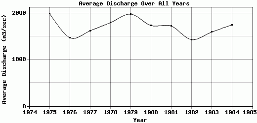
| 1975 | 2810.51 | 4003.72 | 3935.61 | 2148.69 | 1851.2 | 1600.95 | 440.74 | 629.73 | 1744.04 | 1599.09 | 1057.45 | 2003.66 | 1985.45 |
| 1976 | 2872.35 | 3686.29 | 2554.83 | 1311.17 | 716.15 | 608.75 | 1108.56 | 592 | 352.59 | 1469.56 | 1047.92 | 1272.35 | 1466.04 |
| 1977 | 409.04 | 1650.17 | 3579.36 | 3018.69 | 1109.02 | 424.76 | 1027.72 | 1044.17 | 957.26 | 1409.64 | 1416.7 | 3392.74 | 1619.94 |
| 1978 | 2772.51 | 1075.64 | 3472.58 | 2627.82 | 3187.12 | 1415.94 | 1016.67 | 743.81 | 458.84 | 617.13 | 689.42 | 3435.13 | 1792.72 |
| 1979 | 3358.49 | 2422.11 | 3654.81 | 2606.2 | 1874.04 | 903.31 | 613.11 | 1265.86 | 1475.32 | 1992.51 | 1614.45 | 1908.2 | 1974.03 |
| 1980 | 1674.81 | 1019.12 | 3246.5 | 3630.9 | 1779.95 | 1903.94 | 1259.47 | 2684.91 | 737.47 | 564.33 | 1025.74 | 1262.3 | 1732.45 |
| 1981 | 755.06 | 3866.59 | 2130.08 | 2843.31 | 2297.42 | 3160.74 | 830.05 | 477.75 | 824.69 | 836.54 | 1080.77 | 1544.1 | 1720.59 |
| 1982 | 1839.51 | 3048.12 | 3597.17 | 1737.81 | 731.77 | 1409.34 | 806.26 | 382.6 | 371.77 | 304.98 | 926.91 | 1995.89 | 1429.34 |
| 1983 | 1227.22 | 1633.69 | 1922.27 | 3292.42 | 3770.09 | 1068.68 | 718.12 | 384.44 | 281.32 | 471.96 | 1447.75 | 2860.93 | 1589.91 |
| 1984 | 1013.93 | 2796.16 | 3046.09 | 3554.54 | 2537.93 | 1334.58 | 1067.55 | 957.48 | 420.38 | 502.53 | 1555.17 | 2176.48 | 1746.9 |
| 1985 | 1201.98 | 2494.12 | 3509.21 | 2513.42 | 1048.37 | 926.91 | 764.56 | 338.2 | 269.19 | -9999 | -9999 | -9999 | -9999 |
| |
|
|
|
|
|
|
|
|
|
|
|
|
|
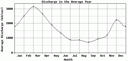
| Avg | 1812.31 | 2517.79 | 3149.86 | 2662.27 | 1900.28 | 1341.63 | 877.53 | 863.72 | 717.53 | 935.3 | 1198.65 | 2236.48 | 1705.74 |
| |
|
|
|
|
|
|
|
|
|
|
|
|
|
| Std Dev | 948.28 |
1027.85 |
633.27 |
691.61 |
946.45 |
708.34 |
230.31 |
643.08 |
476.4 |
546.81 |
277.1 |
739.06 |
177.49 |
| |
|
|
|
|
|
|
|
|
|
|
|
|
|
| | Jan | Feb | Mar | Apr | May | Jun | Jul | Aug | Sep | Oct | Nov | Dec | Avg Annual |
Click here for this table in tab-delimited format.
Tab-delimited format will open in most table browsing software, i.e. Excel, etc.
View this station on the map.
Return to start.