Results
| Country: | U.S.A.
| | Station: | POMEROY, OH | | River: | OHIO R | | Area: | 104888.78 | | Lat: | 38.84 | | Lon: | -82.14 | | Source: | USGS | | PointID: | 3160000 | | Area Units: | km2 | | Discharge Units: | m3/sec | | Starting Year: | 1966 | | Ending Year: | 1969 | | Total Years: | 4 | | Total Usable Years: | 1 | |
| |
| Year | Jan | Feb | Mar | Apr | May | Jun | Jul | Aug | Sep | Oct | Nov | Dec | Avg Annual |
|---|
| 1966 | -9999 | -9999 | 1908.47 | 2006.16 | 2548.07 | -9999 | -9999 | -9999 | -9999 | -9999 | -9999 | 1741.95 | -9999 |
| 1967 | -9999 | 1471.17 | 4818.73 | 2415.53 | 3549.31 | -9999 | -9999 | -9999 | -9999 | 827.95 | 1049.99 | 1660.66 | -9999 |
| 1968 | 1366.52 | 2097.7 | 2254.4 | 1374.04 | 2791.33 | 1322.78 | -9999 | 34.99 | -9999 | -9999 | -9999 | -9999 | -9999 |
| 1969 | -9999 | -9999 | -9999 | -9999 | -9999 | -9999 | -9999 | -9999 | -9999 | 179.16 | 249.19 | -9999 | -9999 |
| |
|
|
|
|
|
|
|
|
|
|
|
|
|
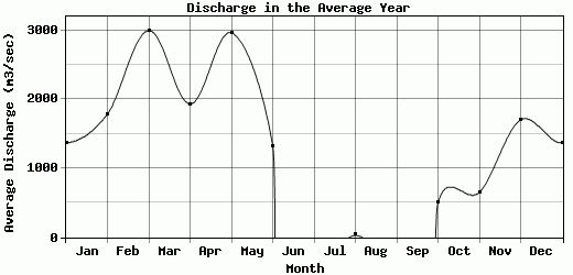
| Avg | 1366.52 | 1784.44 | 2993.87 | 1931.91 | 2962.9 | 1322.78 | 0 | 34.99 | 0 | 503.56 | 649.59 | 1701.31 | -9999 |
| |
|
|
|
|
|
|
|
|
|
|
|
|
|
| Std Dev | 0 |
313.27 |
1298.08 |
428.42 |
426.38 |
0 |
0 |
0 |
0 |
324.4 |
400.4 |
40.65 |
0 |
| |
|
|
|
|
|
|
|
|
|
|
|
|
|
| | Jan | Feb | Mar | Apr | May | Jun | Jul | Aug | Sep | Oct | Nov | Dec | Avg Annual |
Click here for this table in tab-delimited format.
Tab-delimited format will open in most table browsing software, i.e. Excel, etc.
View this station on the map.
Return to start.