Results
| Country: | U.S.A.
| | Station: | GRAFTON, IL | | River: | MISSISSIPPI RIVER | | Area: | 443640.70 | | Lat: | 38.97 | | Lon: | -90.42 | | Source: | USGS | | PointID: | 5587450 | | Area Units: | km2 | | Discharge Units: | m3/sec | | Starting Year: | 1986 | | Ending Year: | 1992 | | Total Years: | 7 | | Total Usable Years: | 6 | |
| |
| Year | Jan | Feb | Mar | Apr | May | Jun | Jul | Aug | Sep | Oct | Nov | Dec | Avg Annual |
|---|
| 1986 | -9999 | -9999 | -9999 | -9999 | -9999 | -9999 | -9999 | -9999 | -9999 | 9482.54 | 4851.65 | 3683.49 | -9999 |
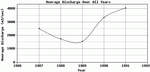
| 1987 | 2538.02 | 2624.38 | 3066.82 | 3921.9 | 2563.88 | 2464.15 | 2031.88 | 2345.29 | 2214.58 | 1748.25 | 1865.71 | 2746.57 | 2510.95 |
| 1988 | 2461.11 | 2862.95 | 3035.49 | 3715.57 | 1957.8 | 1028.28 | 861.48 | 1054.21 | 1071.89 | 794.15 | 973.92 | 981.6 | 1733.2 |
| 1989 | 1105.37 | 1159.28 | 2045.13 | 3162.25 | 1972.6 | 2109.52 | 1199.27 | 1058.6 | 1765.66 | 1080.43 | 942.01 | 900.66 | 1541.73 |
| 1990 | 985.52 | 1516.27 | 4521.13 | 2338.04 | 5262.85 | 6679.04 | 5649.7 | 3794.02 | 2581.28 | 1879.97 | 2051 | 2708.29 | 3330.59 |
| 1991 | 2798.27 | 3018.39 | 4817.18 | 7014.12 | 7022.62 | 6312.8 | 3701.31 | 2326.83 | 2063.46 | 1830.01 | 3280.24 | 4427.5 | 4051.06 |
| 1992 | 2670.57 | 2936.28 | 5268.79 | 5058.36 | 4149.26 | 2002.2 | 3311.72 | 2447.96 | 2799.04 | -9999 | -9999 | -9999 | -9999 |
| |
|
|
|
|
|
|
|
|
|
|
|
|
|
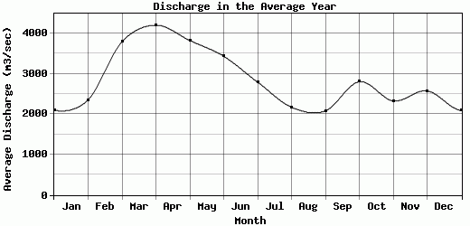
| Avg | 2093.14 | 2352.92 | 3792.42 | 4201.71 | 3821.5 | 3432.67 | 2792.56 | 2171.15 | 2082.65 | 2802.56 | 2327.42 | 2574.69 | 2633.51 |
| |
|
|
|
|
|
|
|
|
|
|
|
|
|
| Std Dev | 749.05 |
735.04 |
1148.43 |
1500.66 |
1866.61 |
2211.72 |
1638.34 |
935.43 |
562.99 |
3014.69 |
1373.59 |
1294.22 |
950.05 |
| |
|
|
|
|
|
|
|
|
|
|
|
|
|
| | Jan | Feb | Mar | Apr | May | Jun | Jul | Aug | Sep | Oct | Nov | Dec | Avg Annual |
Click here for this table in tab-delimited format.
Tab-delimited format will open in most table browsing software, i.e. Excel, etc.
View this station on the map.
Return to start.