Results
| Country: | U.S.A.
| | Station: | HINSDALE, MT. | | River: | MILK RIVER | | Area: | 26027988.30 | | Lat: | 48.4 | | Lon: | -107.07 | | Source: | USGS | | PointID: | 6171500 | | Area Units: | km2 | | Discharge Units: | m3/sec | | Starting Year: | 1908 | | Ending Year: | 1914 | | Total Years: | 7 | | Total Usable Years: | 5 | |
| |
| Year | Jan | Feb | Mar | Apr | May | Jun | Jul | Aug | Sep | Oct | Nov | Dec | Avg Annual |
|---|
| 1908 | -9999 | -9999 | -9999 | -9999 | 4.81 | 55.37 | 9.85 | 3.22 | 2.04 | 1.89 | 3.4 | -9999 | -9999 |
| 1909 | -9999 | -9999 | -9999 | 30.77 | 52.4 | 105.06 | 62.14 | 12.81 | 1.67 | 2.02 | 2.74 | 2.27 | -9999 |
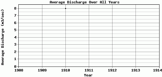
| 1910 | 1.56 | 1.7 | 70.79 | 16.46 | 2.09 | 1.79 | 0.2 | 0.73 | 0.18 | 0.06 | 0.08 | 0.08 | 7.98 |
| 1911 | -9999 | -9999 | 14.36 | 18.03 | 13.5 | 15.88 | 11.84 | 1.8 | 98.13 | 39.86 | 5.29 | 1.42 | -9999 |
| 1912 | -9999 | -9999 | -9999 | 365.69 | 91.11 | 48.77 | 17.11 | 24.89 | 9.55 | 7.79 | 7.5 | -9999 | -9999 |
| 1913 | -9999 | -9999 | -9999 | 106.19 | 37.02 | 19.91 | 12.99 | 2.4 | 1.4 | 2.18 | 3.03 | -9999 | -9999 |
| 1914 | -9999 | -9999 | -9999 | 26.39 | 2.91 | 16.14 | 4.44 | 6.22 | 1.48 | 11.27 | 4.53 | -9999 | -9999 |
| |
|
|
|
|
|
|
|
|
|
|
|
|
|
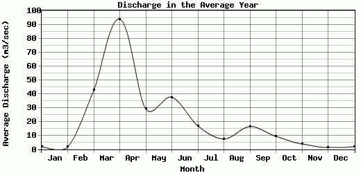
| Avg | 1.56 | 1.7 | 42.58 | 93.92 | 29.12 | 37.56 | 16.94 | 7.44 | 16.35 | 9.3 | 3.8 | 1.26 | 7.98 |
| |
|
|
|
|
|
|
|
|
|
|
|
|
|
| Std Dev | 0 |
0 |
28.22 |
125.38 |
30.94 |
32.77 |
19.17 |
8.06 |
33.51 |
13.01 |
2.14 |
0.9 |
0 |
| |
|
|
|
|
|
|
|
|
|
|
|
|
|
| | Jan | Feb | Mar | Apr | May | Jun | Jul | Aug | Sep | Oct | Nov | Dec | Avg Annual |
Click here for this table in tab-delimited format.
Tab-delimited format will open in most table browsing software, i.e. Excel, etc.
View this station on the map.
Return to start.