Results
| Country: | U.S.A.
| | Station: | MIZPAH, MT. | | River: | POWDER RIVER | | Area: | 26132092.36 | | Lat: | 46.25 | | Lon: | -105.27 | | Source: | USGS | | PointID: | 6326000 | | Area Units: | km2 | | Discharge Units: | m3/sec | | Starting Year: | 1928 | | Ending Year: | 1933 | | Total Years: | 6 | | Total Usable Years: | 4 | |
| |
| Year | Jan | Feb | Mar | Apr | May | Jun | Jul | Aug | Sep | Oct | Nov | Dec | Avg Annual |
|---|
| 1928 | -9999 | -9999 | -9999 | -9999 | -9999 | -9999 | -9999 | 10.48 | 5.46 | 7.96 | 10.23 | 8.5 | -9999 |
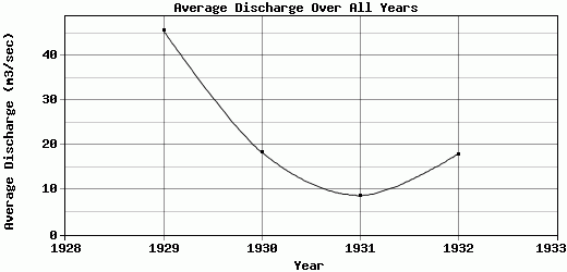
| 1929 | 7.08 | 4.25 | 155.74 | 92.95 | 107.56 | 117.21 | 26.46 | 4.3 | 6.32 | 8.52 | 9.91 | 8.5 | 45.73 |
| 1930 | 5.66 | 70.79 | 25.49 | 18.44 | 22.8 | 19.36 | 9.45 | 20.89 | 8.7 | 9.89 | 4.6 | 5.29 | 18.45 |
| 1931 | 2.93 | 5.37 | 10.68 | 13.13 | 26.42 | 22.43 | 4.6 | 11.09 | 0.41 | 2.91 | 3.48 | 1.84 | 8.77 |
| 1932 | 1.7 | 19.82 | 24.07 | 26.51 | 58.83 | 60.18 | 10.4 | 1.9 | 0.08 | 3.12 | 6.96 | 2.54 | 18.01 |
| 1933 | 3.38 | 0.28 | 13.22 | -9999 | -9999 | -9999 | -9999 | -9999 | -9999 | -9999 | -9999 | -9999 | -9999 |
| |
|
|
|
|
|
|
|
|
|
|
|
|
|
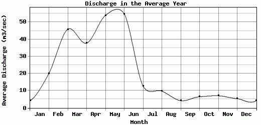
| Avg | 4.15 | 20.1 | 45.84 | 37.76 | 53.9 | 54.8 | 12.73 | 9.73 | 4.19 | 6.48 | 7.04 | 5.33 | 22.74 |
| |
|
|
|
|
|
|
|
|
|
|
|
|
|
| Std Dev | 1.95 |
26.19 |
55.26 |
32.22 |
34.01 |
39.46 |
8.23 |
6.6 |
3.4 |
2.9 |
2.72 |
2.83 |
13.82 |
| |
|
|
|
|
|
|
|
|
|
|
|
|
|
| | Jan | Feb | Mar | Apr | May | Jun | Jul | Aug | Sep | Oct | Nov | Dec | Avg Annual |
Click here for this table in tab-delimited format.
Tab-delimited format will open in most table browsing software, i.e. Excel, etc.
View this station on the map.
Return to start.