Results
| Country: | U.S.A.
| | Station: | PARKERTON WYO | | River: | NORTH PLATTE RIVER | | Area: | 44377.02 | | Lat: | 42.85 | | Lon: | -105.98 | | Source: | USGS | | PointID: | 6645500 | | Area Units: | km2 | | Discharge Units: | m3/sec | | Starting Year: | 1919 | | Ending Year: | 1924 | | Total Years: | 6 | | Total Usable Years: | 3 | |
| |
| Year | Jan | Feb | Mar | Apr | May | Jun | Jul | Aug | Sep | Oct | Nov | Dec | Avg Annual |
|---|
| 1919 | -9999 | -9999 | -9999 | -9999 | 87.27 | 142.14 | 102.38 | 98.27 | 59.74 | -9999 | -9999 | -9999 | -9999 |
| 1920 | -9999 | -9999 | -9999 | -9999 | 41.14 | 230.31 | 149.28 | 113.43 | 67.48 | -9999 | -9999 | -9999 | -9999 |
| 1921 | -9999 | -9999 | -9999 | 41.15 | 59.15 | 303.75 | 153.65 | 133.89 | 88.84 | -9999 | -9999 | -9999 | -9999 |
| 1922 | -9999 | -9999 | -9999 | -9999 | 131.06 | 136.41 | 124.27 | 109.61 | 81.99 | -9999 | -9999 | -9999 | -9999 |
| 1923 | -9999 | -9999 | -9999 | 16.17 | 15 | 102.3 | 157.14 | 107.61 | 104.91 | -9999 | -9999 | -9999 | -9999 |
| 1924 | -9999 | -9999 | -9999 | 110.76 | 188.17 | 162.74 | 188.15 | 163.19 | 97.17 | -9999 | -9999 | -9999 | -9999 |
| |
|
|
|
|
|
|
|
|
|
|
|
|
|
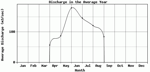
| Avg | 0 | 0 | 0 | 56.03 | 86.96 | 179.61 | 145.81 | 121 | 83.36 | 0 | 0 | -9999 | -9999 |
| |
|
|
|
|
|
|
|
|
|
|
|
|
|
| Std Dev | 0 |
0 |
0 |
40.02 |
58.08 |
67.72 |
26.91 |
21.71 |
15.8 |
0 |
0 |
0 |
0 |
| |
|
|
|
|
|
|
|
|
|
|
|
|
|
| | Jan | Feb | Mar | Apr | May | Jun | Jul | Aug | Sep | Oct | Nov | Dec | Avg Annual |
Click here for this table in tab-delimited format.
Tab-delimited format will open in most table browsing software, i.e. Excel, etc.
View this station on the map.
Return to start.