Results
| Country: | U.S.A.
| | Station: | LAKIN, KS | | River: | ARKANSAS R | | Area: | 72096.15 | | Lat: | 37.92 | | Lon: | -101.25 | | Source: | USGS | | PointID: | 7138065 | | Area Units: | km2 | | Discharge Units: | m3/sec | | Starting Year: | 1978 | | Ending Year: | 1982 | | Total Years: | 5 | | Total Usable Years: | 4 | |
| |
| Year | Jan | Feb | Mar | Apr | May | Jun | Jul | Aug | Sep | Oct | Nov | Dec | Avg Annual |
|---|
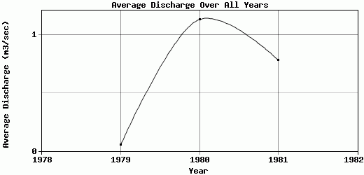
| 1978 | -9999 | -9999 | -9999 | 0.05 | 0.41 | 2.04 | 0 | 0.01 | 0 | 0 | 0 | 0 | -9999 |
| 1979 | 0 | 0 | 0 | 0 | 0 | 0.08 | 0.46 | 0.03 | 0 | 0 | 0 | 0 | 0.05 |
| 1980 | 0 | 0 | 0 | 1.32 | 1.32 | 1.64 | 5.09 | 3.21 | 0 | 0 | 0.1 | 0.91 | 1.13 |
| 1981 | 1.18 | 1.03 | 1.23 | 0.29 | 0.24 | 0.18 | 1 | 3.11 | 0.52 | 0.09 | 0.19 | 0.32 | 0.78 |
| 1982 | 0.31 | 0.79 | 0.51 | 0.12 | 0.33 | 0.11 | 3.56 | 0.09 | 2.81 | 3.53 | -9999 | -9999 | -9999 |
| |
|
|
|
|
|
|
|
|
|
|
|
|
|
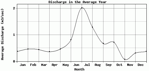
| Avg | 0.37 | 0.46 | 0.44 | 0.36 | 0.46 | 0.81 | 2.02 | 1.29 | 0.67 | 0.72 | 0.07 | 0.31 | 0.65 |
| |
|
|
|
|
|
|
|
|
|
|
|
|
|
| Std Dev | 0.48 |
0.46 |
0.5 |
0.49 |
0.45 |
0.85 |
1.97 |
1.53 |
1.09 |
1.4 |
0.08 |
0.37 |
0.45 |
| |
|
|
|
|
|
|
|
|
|
|
|
|
|
| | Jan | Feb | Mar | Apr | May | Jun | Jul | Aug | Sep | Oct | Nov | Dec | Avg Annual |
Click here for this table in tab-delimited format.
Tab-delimited format will open in most table browsing software, i.e. Excel, etc.
View this station on the map.
Return to start.