Results
| Country: | U.S.A.
| | Station: | WHITNEY DAM NR WHITNEY, TX | | River: | BRAZOS RIVER | | Area: | 67828.08 | | Lat: | 31.87 | | Lon: | -97.37 | | Source: | USGS | | PointID: | 8092600 | | Area Units: | km2 | | Discharge Units: | m3/sec | | Starting Year: | 1987 | | Ending Year: | 1991 | | Total Years: | 5 | | Total Usable Years: | 4 | |
| |
| Year | Jan | Feb | Mar | Apr | May | Jun | Jul | Aug | Sep | Oct | Nov | Dec | Avg Annual |
|---|
| 1987 | -9999 | -9999 | -9999 | -9999 | -9999 | -9999 | -9999 | -9999 | -9999 | 13.06 | 12.65 | 17.83 | -9999 |
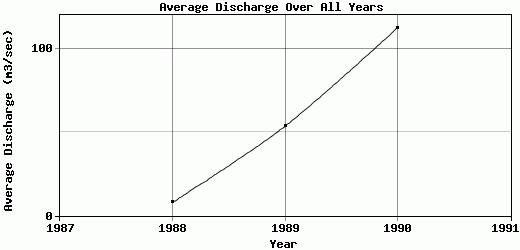
| 1988 | 16.85 | 12.2 | 7.19 | 8.95 | 0.37 | 13.56 | 12.51 | 1.74 | 4.47 | 0.69 | 0.75 | 14.43 | 7.81 |
| 1989 | 0.97 | 1.77 | 5.58 | 10.37 | 175.37 | 323.12 | 36.02 | 24.38 | 19.67 | 17.28 | 6.96 | 19.74 | 53.44 |
| 1990 | 10.55 | 10.76 | 75.77 | 206.28 | 652.11 | 298.56 | 16.59 | 19.09 | 11.64 | 24.62 | 11.6 | 10.88 | 112.37 |
| 1991 | 15.87 | 17.12 | 10.08 | 43.5 | 49.03 | 204.29 | 18.1 | 39.65 | 26.23 | -9999 | -9999 | -9999 | -9999 |
| |
|
|
|
|
|
|
|
|
|
|
|
|
|
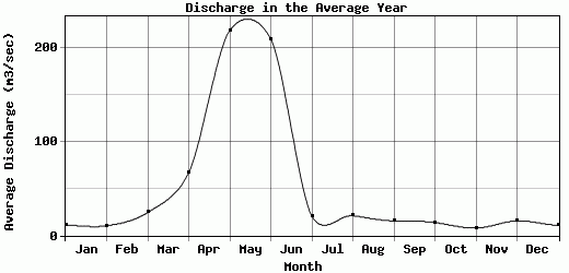
| Avg | 11.06 | 10.46 | 24.65 | 67.28 | 219.22 | 209.88 | 20.81 | 21.21 | 15.5 | 13.91 | 7.99 | 15.72 | 57.87 |
| |
|
|
|
|
|
|
|
|
|
|
|
|
|
| Std Dev | 6.3 |
5.55 |
29.56 |
81.44 |
257.96 |
121.72 |
9.02 |
13.54 |
8.2 |
8.68 |
4.7 |
3.38 |
42.8 |
| |
|
|
|
|
|
|
|
|
|
|
|
|
|
| | Jan | Feb | Mar | Apr | May | Jun | Jul | Aug | Sep | Oct | Nov | Dec | Avg Annual |
Click here for this table in tab-delimited format.
Tab-delimited format will open in most table browsing software, i.e. Excel, etc.
View this station on the map.
Return to start.