Results
| Country: | U.S.A.
| | Station: | FORT SUMNER, N. MEX. | | River: | PECOS RIVER | | Area: | 14503.14 | | Lat: | 34.34 | | Lon: | -104.17 | | Source: | USGS | | PointID: | 8385520 | | Area Units: | km2 | | Discharge Units: | m3/sec | | Starting Year: | 1957 | | Ending Year: | 1970 | | Total Years: | 14 | | Total Usable Years: | 9 | |
| |
| Year | Jan | Feb | Mar | Apr | May | Jun | Jul | Aug | Sep | Oct | Nov | Dec | Avg Annual |
|---|
| 1957 | -9999 | -9999 | -9999 | -9999 | -9999 | -9999 | -9999 | 1.2 | 1.48 | 1.14 | 0.63 | 0.42 | -9999 |
| 1958 | 0.43 | 0.31 | 0.84 | 0.77 | -9999 | -9999 | -9999 | -9999 | -9999 | -9999 | -9999 | -9999 | -9999 |
| 1959 | -9999 | -9999 | -9999 | -9999 | -9999 | -9999 | -9999 | -9999 | -9999 | -9999 | -9999 | -9999 | -9999 |
| 1960 | -9999 | -9999 | -9999 | -9999 | -9999 | -9999 | -9999 | -9999 | -9999 | -9999 | -9999 | -9999 | -9999 |
| 1961 | -9999 | -9999 | -9999 | -9999 | -9999 | -9999 | -9999 | -9999 | -9999 | -9999 | -9999 | -9999 | -9999 |
| 1962 | -9999 | -9999 | 1.46 | 0.96 | 0.77 | 5.13 | 1.6 | 0.93 | 1.57 | 1.02 | 0.94 | 0.74 | -9999 |
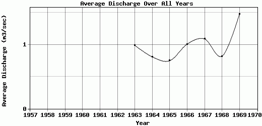
| 1963 | 0.68 | 0.67 | 0.93 | 0.9 | 0.83 | 1.34 | 0.8 | 1.82 | 1.38 | 1.25 | 0.78 | 0.51 | 0.99 |
| 1964 | 0.4 | 0.39 | 0.79 | 1.55 | 0.84 | 0.73 | 1.2 | 0.77 | 0.91 | 0.95 | 0.74 | 0.48 | 0.81 |
| 1965 | 0.4 | 0.37 | 0.33 | 0.87 | 0.83 | 0.63 | 0.99 | 1.2 | 1.18 | 1.16 | 0.56 | 0.46 | 0.75 |
| 1966 | 0.42 | 0.49 | 1.19 | 0.99 | 0.88 | 0.81 | 0.99 | 2.45 | 1.56 | 1.16 | 0.68 | 0.47 | 1.01 |
| 1967 | 0.59 | 0.5 | 0.8 | 0.84 | 3.2 | 1.06 | 0.74 | 1.75 | 1.12 | 1.21 | 0.75 | 0.51 | 1.09 |
| 1968 | 0.42 | 0.43 | 0.49 | 1.02 | 0.84 | 0.78 | 1.4 | 0.89 | 0.87 | 1.46 | 0.69 | 0.52 | 0.82 |
| 1969 | 0.57 | 0.68 | 0.53 | 1.36 | 1.15 | 1.12 | 2.24 | 2.73 | 3.77 | 2.05 | 0.93 | 0.66 | 1.48 |
| 1970 | 0.53 | 0.46 | 0.73 | 1.19 | 0.67 | 1.79 | 0.9 | 1.87 | 1.14 | -9999 | -9999 | -9999 | -9999 |
| |
|
|
|
|
|
|
|
|
|
|
|
|
|
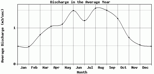
| Avg | 0.49 | 0.48 | 0.81 | 1.05 | 1.11 | 1.49 | 1.21 | 1.56 | 1.5 | 1.27 | 0.74 | 0.53 | 0.99 |
| |
|
|
|
|
|
|
|
|
|
|
|
|
|
| Std Dev | 0.1 |
0.12 |
0.32 |
0.24 |
0.75 |
1.33 |
0.45 |
0.64 |
0.79 |
0.31 |
0.12 |
0.1 |
0.23 |
| |
|
|
|
|
|
|
|
|
|
|
|
|
|
| | Jan | Feb | Mar | Apr | May | Jun | Jul | Aug | Sep | Oct | Nov | Dec | Avg Annual |
Click here for this table in tab-delimited format.
Tab-delimited format will open in most table browsing software, i.e. Excel, etc.
View this station on the map.
Return to start.