Results
| Country: | U.S.A.
| | Station: | BEND BRIDGE NR RED BLUFF CA | | River: | SACRAMENTO R | | Area: | 23049.63 | | Lat: | 40.26 | | Lon: | -122.22 | | Source: | USGS | | PointID: | 11377200 | | Area Units: | km2 | | Discharge Units: | m3/sec | | Starting Year: | 1967 | | Ending Year: | 1970 | | Total Years: | 4 | | Total Usable Years: | 3 | |
| |
| Year | Jan | Feb | Mar | Apr | May | Jun | Jul | Aug | Sep | Oct | Nov | Dec | Avg Annual |
|---|
| 1967 | -9999 | -9999 | -9999 | -9999 | -9999 | -9999 | -9999 | -9999 | -9999 | 275.64 | 226.08 | 272.11 | -9999 |
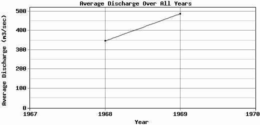
| 1968 | 338.05 | 686.27 | 391.51 | 272 | 276.46 | 319.59 | 402.28 | 365.65 | 297.05 | 224.67 | 223.36 | 352.78 | 345.81 |
| 1969 | 963.65 | 1132.28 | 404.49 | 335.3 | 455.54 | 427.68 | 354.15 | 341.17 | 275.72 | 238.65 | 235.15 | 676.1 | 486.66 |
| 1970 | 1729.16 | 1100.72 | 361.24 | 268.01 | 269.57 | 291.85 | 305.91 | 269.82 | 231.57 | -9999 | -9999 | -9999 | -9999 |
| |
|
|
|
|
|
|
|
|
|
|
|
|
|
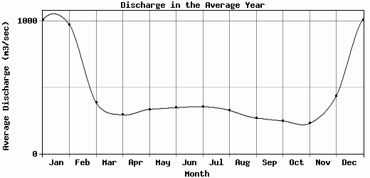
| Avg | 1010.29 | 973.09 | 385.75 | 291.77 | 333.86 | 346.37 | 354.11 | 325.55 | 268.11 | 246.32 | 228.2 | 433.66 | 416.24 |
| |
|
|
|
|
|
|
|
|
|
|
|
|
|
| Std Dev | 568.87 |
203.22 |
18.12 |
30.82 |
86.09 |
58.6 |
39.34 |
40.65 |
27.27 |
21.5 |
5.04 |
174.56 |
70.43 |
| |
|
|
|
|
|
|
|
|
|
|
|
|
|
| | Jan | Feb | Mar | Apr | May | Jun | Jul | Aug | Sep | Oct | Nov | Dec | Avg Annual |
Click here for this table in tab-delimited format.
Tab-delimited format will open in most table browsing software, i.e. Excel, etc.
View this station on the map.
Return to start.