Results
| Country: | U.S.A.
| | Station: | 7 MILE BRIDGE NR SPOKANE WASH | | River: | SPOKANE R | | Area: | 13001.03 | | Lat: | 47.74 | | Lon: | -117.52 | | Source: | USGS | | PointID: | 12424500 | | Area Units: | km2 | | Discharge Units: | m3/sec | | Starting Year: | 1948 | | Ending Year: | 1952 | | Total Years: | 5 | | Total Usable Years: | 4 | |
| |
| Year | Jan | Feb | Mar | Apr | May | Jun | Jul | Aug | Sep | Oct | Nov | Dec | Avg Annual |
|---|
| 1948 | -9999 | -9999 | -9999 | -9999 | -9999 | -9999 | -9999 | -9999 | -9999 | -9999 | 65.16 | 112.69 | -9999 |
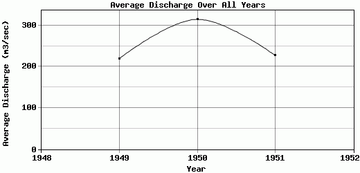
| 1949 | 101.63 | 142.38 | 358.71 | 575.5 | 809.04 | 243.6 | 66.54 | 45.18 | 33.85 | 49.56 | 94.93 | 115.77 | 219.72 |
| 1950 | 142.67 | 235.67 | 549.08 | 598.34 | 721.72 | 692.82 | 225.05 | 64.09 | 42.29 | 82.09 | 144.95 | 280.96 | 314.98 |
| 1951 | 266.5 | 500.64 | 257.18 | 463.36 | 506.87 | 203.45 | 72.99 | 34.19 | 34.47 | 95.91 | 122 | 173.66 | 227.6 |
| 1952 | 143.11 | 198.98 | 176.23 | 543.65 | 677.78 | 208.02 | 85.47 | 38.8 | 54.7 | -9999 | -9999 | -9999 | -9999 |
| |
|
|
|
|
|
|
|
|
|
|
|
|
|
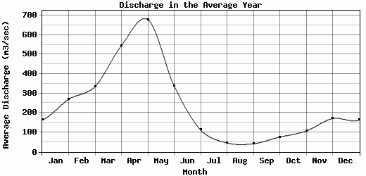
| Avg | 163.48 | 269.42 | 335.3 | 545.21 | 678.85 | 336.97 | 112.51 | 45.57 | 41.33 | 75.85 | 106.76 | 170.77 | 254.1 |
| |
|
|
|
|
|
|
|
|
|
|
|
|
|
| Std Dev | 61.82 |
137.57 |
139.33 |
51.09 |
109.96 |
206.04 |
65.33 |
11.39 |
8.41 |
19.43 |
29.84 |
68.1 |
43.17 |
| |
|
|
|
|
|
|
|
|
|
|
|
|
|
| | Jan | Feb | Mar | Apr | May | Jun | Jul | Aug | Sep | Oct | Nov | Dec | Avg Annual |
Click here for this table in tab-delimited format.
Tab-delimited format will open in most table browsing software, i.e. Excel, etc.
View this station on the map.
Return to start.