Results
| Country: | U.S.A.
| | Station: | LEWISVILLE ID | | River: | SNAKE RIVER | | Area: | 23567.60 | | Lat: | 43.62 | | Lon: | -112.06 | | Source: | USGS | | PointID: | 13057150 | | Area Units: | km2 | | Discharge Units: | m3/sec | | Starting Year: | 1978 | | Ending Year: | 1982 | | Total Years: | 5 | | Total Usable Years: | 4 | |
| |
| Year | Jan | Feb | Mar | Apr | May | Jun | Jul | Aug | Sep | Oct | Nov | Dec | Avg Annual |
|---|
| 1978 | -9999 | -9999 | -9999 | -9999 | -9999 | 361.56 | 240.82 | 151.4 | 123.03 | 86.42 | 118.55 | 176.26 | -9999 |
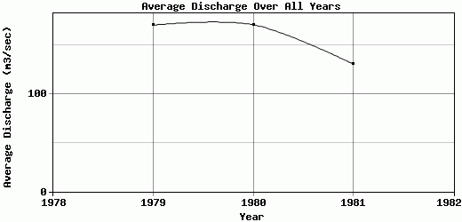
| 1979 | 189.38 | 179.78 | 232.15 | 258.78 | 269.38 | 267.53 | 203.86 | 136.31 | 100.63 | 59.37 | 67.03 | 84.91 | 170.76 |
| 1980 | 90.32 | 97.92 | 82.75 | 192.98 | 427.95 | 472.71 | 225.19 | 152.67 | 91.98 | 68.17 | 70.41 | 80.39 | 171.12 |
| 1981 | 74.56 | 75.33 | 66.54 | 133.44 | 290.45 | 395.62 | 166.8 | 117.5 | 90.91 | 43.46 | 54.09 | 61.9 | 130.88 |
| 1982 | 70.26 | 87.48 | 241.41 | 387.39 | 576.11 | 363.68 | 403.51 | 148.27 | 135.67 | 155.8 | 148.23 | -9999 | -9999 |
| |
|
|
|
|
|
|
|
|
|
|
|
|
|
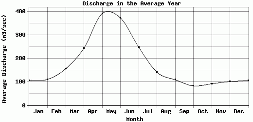
| Avg | 106.13 | 110.13 | 155.71 | 243.15 | 390.97 | 372.22 | 248.04 | 141.23 | 108.44 | 82.64 | 91.66 | 100.86 | 157.59 |
| |
|
|
|
|
|
|
|
|
|
|
|
|
|
| Std Dev | 48.64 |
41 |
81.34 |
94.34 |
123.02 |
66.02 |
81.61 |
13.2 |
17.85 |
39.12 |
35.76 |
44.37 |
18.89 |
| |
|
|
|
|
|
|
|
|
|
|
|
|
|
| | Jan | Feb | Mar | Apr | May | Jun | Jul | Aug | Sep | Oct | Nov | Dec | Avg Annual |
Click here for this table in tab-delimited format.
Tab-delimited format will open in most table browsing software, i.e. Excel, etc.
View this station on the map.
Return to start.