Results
| Country: | U.S.A.
| | Station: | PORTERVILLE BRIDGE NR BLACKFOOT I | | River: | SNAKE RIVER | | Area: | 25743.07 | | Lat: | 43.23 | | Lon: | -112.33 | | Source: | USGS | | PointID: | 13062000 | | Area Units: | km2 | | Discharge Units: | m3/sec | | Starting Year: | 1916 | | Ending Year: | 1923 | | Total Years: | 8 | | Total Usable Years: | 4 | |
| |
| Year | Jan | Feb | Mar | Apr | May | Jun | Jul | Aug | Sep | Oct | Nov | Dec | Avg Annual |
|---|
| 1916 | -9999 | -9999 | -9999 | -9999 | -9999 | 489.74 | 287.55 | 191.35 | 133.69 | -9999 | -9999 | -9999 | -9999 |
| 1917 | -9999 | -9999 | -9999 | -9999 | -9999 | -9999 | -9999 | -9999 | -9999 | -9999 | -9999 | -9999 | -9999 |
| 1918 | -9999 | -9999 | -9999 | -9999 | 268.58 | 1045.79 | 262.83 | 196.72 | 130.63 | -9999 | -9999 | -9999 | -9999 |
| 1919 | -9999 | -9999 | -9999 | 255.78 | 228.8 | 160.09 | 87.13 | 15.5 | 5.44 | 42.05 | 79.36 | -9999 | -9999 |
| 1920 | -9999 | -9999 | -9999 | 88.21 | 402.07 | 333.25 | 190.76 | 141.21 | 55.12 | -9999 | -9999 | -9999 | -9999 |
| 1921 | -9999 | -9999 | -9999 | -9999 | 801.37 | 556.23 | 194.65 | 132.97 | 69.24 | 56.78 | -9999 | -9999 | -9999 |
| 1922 | -9999 | -9999 | -9999 | -9999 | 597.89 | 382.02 | 187.82 | 124.48 | 54.03 | 30.87 | -9999 | -9999 | -9999 |
| 1923 | -9999 | -9999 | -9999 | -9999 | 371.74 | 343.29 | 208.67 | 118.75 | 61.27 | -9999 | -9999 | -9999 | -9999 |
| |
|
|
|
|
|
|
|
|
|
|
|
|
|
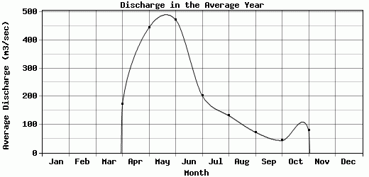
| Avg | 0 | 0 | 0 | 172 | 445.08 | 472.92 | 202.77 | 131.57 | 72.77 | 43.23 | 79.36 | -9999 | -9999 |
| |
|
|
|
|
|
|
|
|
|
|
|
|
|
| Std Dev | 0 |
0 |
0 |
83.79 |
198.1 |
261.27 |
59.32 |
55.55 |
42.09 |
10.61 |
0 |
0 |
0 |
| |
|
|
|
|
|
|
|
|
|
|
|
|
|
| | Jan | Feb | Mar | Apr | May | Jun | Jul | Aug | Sep | Oct | Nov | Dec | Avg Annual |
Click here for this table in tab-delimited format.
Tab-delimited format will open in most table browsing software, i.e. Excel, etc.
View this station on the map.
Return to start.