Results
| Country: | U.S.A.
| | Station: | JUNEAU AK | | River: | TAKU R | | Area: | 17092.99 | | Lat: | 58.54 | | Lon: | -133.7 | | Source: | USGS | | PointID: | 15041200 | | Area Units: | km2 | | Discharge Units: | m3/sec | | Starting Year: | 1987 | | Ending Year: | 1993 | | Total Years: | 7 | | Total Usable Years: | 6 | |
| |
| Year | Jan | Feb | Mar | Apr | May | Jun | Jul | Aug | Sep | Oct | Nov | Dec | Avg Annual |
|---|
| 1987 | -9999 | -9999 | -9999 | -9999 | -9999 | -9999 | 1138.97 | 721.72 | 593.27 | 468.24 | 197.27 | 84.01 | -9999 |
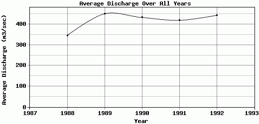
| 1988 | 31.86 | 53.55 | 59.49 | 107.36 | 572.82 | 867.54 | 747.2 | 690.93 | 431.74 | 338.65 | 116.04 | 131.58 | 345.73 |
| 1989 | 75.38 | 56.15 | 39.78 | 144.87 | 866.5 | 1086.05 | 1019.69 | 918.93 | 566.93 | 339.24 | 161.1 | 136.84 | 450.96 |
| 1990 | 68.74 | 39.86 | 72.36 | 157.91 | 697.88 | 1169.3 | 1016.58 | 910.35 | 695.18 | 232.41 | 74.86 | 62.41 | 433.15 |
| 1991 | 47.46 | 55.58 | 38.47 | 138.13 | 642.16 | 1023.66 | 840.74 | 776.34 | 732.75 | 488.57 | 144.83 | 103.65 | 419.36 |
| 1992 | 108.29 | 104.26 | 297.25 | 192.98 | 565.61 | 1395.37 | 1163.28 | 813.79 | 316.65 | 192.26 | 101.68 | 72.65 | 443.67 |
| 1993 | 41.09 | 70.81 | 86.4 | 165.3 | 957.02 | 1125.88 | 952.27 | 639.51 | 595.15 | -9999 | -9999 | -9999 | -9999 |
| |
|
|
|
|
|
|
|
|
|
|
|
|
|
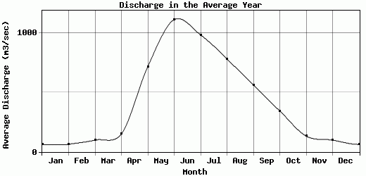
| Avg | 62.14 | 63.37 | 98.96 | 151.09 | 717 | 1111.3 | 982.68 | 781.65 | 561.67 | 343.23 | 132.63 | 98.52 | 418.57 |
| |
|
|
|
|
|
|
|
|
|
|
|
|
|
| Std Dev | 25.57 |
20.37 |
90.28 |
26.21 |
146.99 |
159.17 |
139.43 |
98.92 |
134.25 |
109.44 |
40.22 |
28.2 |
37.94 |
| |
|
|
|
|
|
|
|
|
|
|
|
|
|
| | Jan | Feb | Mar | Apr | May | Jun | Jul | Aug | Sep | Oct | Nov | Dec | Avg Annual |
Click here for this table in tab-delimited format.
Tab-delimited format will open in most table browsing software, i.e. Excel, etc.
View this station on the map.
Return to start.