Results
| Country: | U.S.A.
| | Station: | GOLD CREEK AK | | River: | SUSITNA R | | Area: | 15953.45 | | Lat: | 62.77 | | Lon: | -149.69 | | Source: | USGS | | PointID: | 15292000 | | Area Units: | km2 | | Discharge Units: | m3/sec | | Starting Year: | 1989 | | Ending Year: | 1993 | | Total Years: | 5 | | Total Usable Years: | 3 | |
| |
| Year | Jan | Feb | Mar | Apr | May | Jun | Jul | Aug | Sep | Oct | Nov | Dec | Avg Annual |
|---|
| 1989 | -9999 | -9999 | -9999 | -9999 | -9999 | -9999 | -9999 | -9999 | -9999 | 227.26 | 84.86 | 52.34 | -9999 |
| 1990 | 49.97 | 48.14 | 52.43 | 120.35 | 725.83 | 957.21 | 665.81 | 672.03 | 750.59 | -9999 | -9999 | -9999 | -9999 |
| 1991 | -9999 | -9999 | -9999 | -9999 | -9999 | -9999 | -9999 | -9999 | -9999 | 164.73 | 69.09 | 62.3 | -9999 |
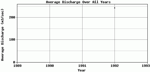
| 1992 | 55.63 | 50.97 | 52.89 | 59.47 | 172.85 | 655.26 | 723.09 | 598.77 | 288.12 | 123.99 | 77.4 | 57.73 | 243.01 |
| 1993 | 52.8 | 49.66 | 46.4 | 71.83 | 591.28 | 664.98 | 547.8 | 530.81 | 602.77 | -9999 | -9999 | -9999 | -9999 |
| |
|
|
|
|
|
|
|
|
|
|
|
|
|
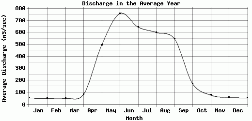
| Avg | 52.8 | 49.59 | 50.57 | 83.88 | 496.65 | 759.15 | 645.57 | 600.54 | 547.16 | 171.99 | 77.12 | 57.46 | 243.01 |
| |
|
|
|
|
|
|
|
|
|
|
|
|
|
| Std Dev | 2.31 |
1.16 |
2.96 |
26.27 |
235.46 |
140.11 |
72.98 |
57.67 |
192.85 |
42.47 |
6.44 |
4.07 |
0 |
| |
|
|
|
|
|
|
|
|
|
|
|
|
|
| | Jan | Feb | Mar | Apr | May | Jun | Jul | Aug | Sep | Oct | Nov | Dec | Avg Annual |
Click here for this table in tab-delimited format.
Tab-delimited format will open in most table browsing software, i.e. Excel, etc.
View this station on the map.
Return to start.