Results
| Country: | U.S.A.
| | Station: | MCGRATH AK | | River: | KUSKOKWIM R | | Area: | 30301.20 | | Lat: | 62.95 | | Lon: | -155.59 | | Source: | USGS | | PointID: | 15303600 | | Area Units: | km2 | | Discharge Units: | m3/sec | | Starting Year: | 1963 | | Ending Year: | 1973 | | Total Years: | 11 | | Total Usable Years: | 10 | |
| |
| Year | Jan | Feb | Mar | Apr | May | Jun | Jul | Aug | Sep | Oct | Nov | Dec | Avg Annual |
|---|
| 1963 | -9999 | -9999 | -9999 | -9999 | -9999 | -9999 | 1136.52 | 1466.09 | 673.94 | 429.82 | 152.91 | 152.91 | -9999 |
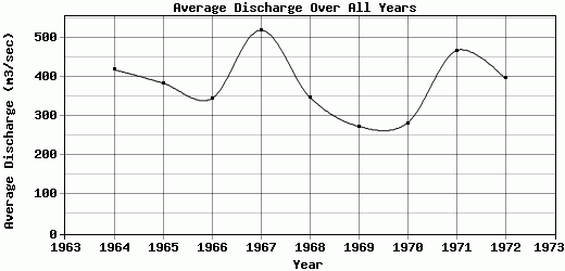
| 1964 | 149.99 | 147.25 | 147.25 | 147.25 | 169.9 | 1385.65 | 1028.36 | 753.14 | 484.43 | 248.37 | 184.06 | 175.57 | 418.43 |
| 1965 | 167.07 | 161.41 | 155.74 | 164.24 | 365.93 | 447.97 | 620.6 | 805.21 | 834.41 | 534.19 | 203.88 | 146.88 | 383.96 |
| 1966 | 108.79 | 90.61 | 79.29 | 109.02 | 630.19 | 782.87 | 681.07 | 635.12 | 451 | 288.47 | 158.58 | 121.76 | 344.73 |
| 1967 | 110.44 | 113.27 | 141.58 | 328.48 | 1004.43 | 841.11 | 1044.9 | 1404.71 | 641.47 | 284.72 | 167.64 | 146.52 | 519.11 |
| 1968 | 137.29 | 130.45 | 127.43 | 133.75 | 835.9 | 691.5 | 728.02 | 590 | 336.97 | 228.36 | 128.75 | 111.72 | 348.35 |
| 1969 | 107.6 | 107.6 | 104.77 | 174.9 | 449.42 | 385.3 | 594.2 | 605.34 | 290.91 | 223.03 | 130.82 | 113.72 | 273.97 |
| 1970 | 113.27 | 113.27 | 110.44 | 150.17 | 422.75 | 351.32 | 627.91 | 558.03 | 405.31 | 272.57 | 143.28 | 118.93 | 282.27 |
| 1971 | 118.93 | 116.1 | 113.27 | 159.8 | 1123.91 | 905.67 | 844.21 | 1035.58 | 472.89 | 404.48 | 168.96 | 141.58 | 467.12 |
| 1972 | 127.43 | 116.2 | 111.08 | 157.63 | 998.04 | 731.33 | 720.07 | 609.73 | 522.64 | 344.01 | 169.43 | 144.33 | 395.99 |
| 1973 | 134.28 | 127.43 | 127.43 | 166.6 | 568.17 | 458.26 | 587.35 | 679.15 | 384.54 | -9999 | -9999 | -9999 | -9999 |
| |
|
|
|
|
|
|
|
|
|
|
|
|
|
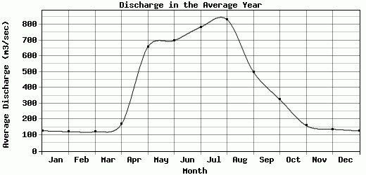
| Avg | 127.51 | 122.36 | 121.83 | 169.18 | 656.86 | 698.1 | 783.02 | 831.1 | 499.86 | 325.8 | 160.83 | 137.39 | 381.55 |
| |
|
|
|
|
|
|
|
|
|
|
|
|
|
| Std Dev | 18.78 |
19.25 |
21.61 |
56.02 |
302.59 |
297.12 |
190.51 |
312.61 |
153.32 |
96.3 |
22.1 |
19.34 |
75.8 |
| |
|
|
|
|
|
|
|
|
|
|
|
|
|
| | Jan | Feb | Mar | Apr | May | Jun | Jul | Aug | Sep | Oct | Nov | Dec | Avg Annual |
Click here for this table in tab-delimited format.
Tab-delimited format will open in most table browsing software, i.e. Excel, etc.
View this station on the map.
Return to start.