Results
| Country: | U.S.A.
| | Station: | NOATAK AK | | River: | NOATAK R | | Area: | 31078.16 | | Lat: | 67.57 | | Lon: | -162.94 | | Source: | USGS | | PointID: | 15746000 | | Area Units: | km2 | | Discharge Units: | m3/sec | | Starting Year: | 1965 | | Ending Year: | 1971 | | Total Years: | 7 | | Total Usable Years: | 3 | |
| |
| Year | Jan | Feb | Mar | Apr | May | Jun | Jul | Aug | Sep | Oct | Nov | Dec | Avg Annual |
|---|
| 1965 | -9999 | -9999 | -9999 | -9999 | -9999 | -9999 | -9999 | 1272.57 | 1600.85 | 155.01 | 8.5 | 0.23 | -9999 |
| 1966 | 0 | 0 | 0 | 3.4 | 68.19 | 1553.09 | 678.01 | 249.68 | 383.46 | 273.21 | -9999 | -9999 | -9999 |
| 1967 | -9999 | -9999 | -9999 | -9999 | 93.45 | 3195.2 | 1402.51 | 851.43 | 348.96 | 123.32 | -9999 | -9999 | -9999 |
| 1968 | -9999 | -9999 | -9999 | -9999 | 56.45 | 2442.81 | 1027.09 | 582.05 | 203.13 | 35.49 | -9999 | -9999 | -9999 |
| 1969 | -9999 | -9999 | -9999 | -9999 | -9999 | -9999 | 976.02 | 1913.22 | 522.64 | 96.87 | -9999 | -9999 | -9999 |
| 1970 | -9999 | -9999 | -9999 | -9999 | -9999 | 488 | 265.91 | 553.28 | 162.3 | 8.52 | -9999 | -9999 | -9999 |
| 1971 | -9999 | -9999 | -9999 | -9999 | -9999 | 2089.51 | 568.17 | 387.58 | 232.39 | -9999 | -9999 | -9999 | -9999 |
| |
|
|
|
|
|
|
|
|
|
|
|
|
|
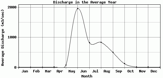
| Avg | 0 | 0 | 0 | 3.4 | 72.7 | 1953.72 | 819.62 | 829.97 | 493.39 | 115.4 | 8.5 | 0.23 | -9999 |
| |
|
|
|
|
|
|
|
|
|
|
|
|
|
| Std Dev | 0 |
0 |
0 |
0 |
15.44 |
906.4 |
364.5 |
539.87 |
466.33 |
86.3 |
0 |
0 |
0 |
| |
|
|
|
|
|
|
|
|
|
|
|
|
|
| | Jan | Feb | Mar | Apr | May | Jun | Jul | Aug | Sep | Oct | Nov | Dec | Avg Annual |
Click here for this table in tab-delimited format.
Tab-delimited format will open in most table browsing software, i.e. Excel, etc.
View this station on the map.
Return to start.