Results
| Country: | U.S.A.
| | Station: | Porter,Washington | | River: | Chehalis | | Area: | 3351 km2 | | Lat: | 46.93 | | Lon: | -123.31 | | Source: | RivDIS | | PointID: | 348 | | Area Units: | km2 | | Discharge Units: | m3/sec | | Starting Year: | 1965 | | Ending Year: | 1972 | | Total Years: | 8 | | Total Usable Years: | 7 | |
| |
| Year | Jan | Feb | Mar | Apr | May | Jun | Jul | Aug | Sep | Oct | Nov | Dec | Avg Annual |
|---|
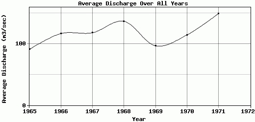
| 1965 | 348 | 282 | 87 | 62 | 47 | 19 | 10 | 9 | 8 | 17 | 73 | 126 | 90.67 |
| 1966 | 316 | 139 | 287 | 92 | 35 | 20 | 17 | 8 | 8 | 28 | 73 | 375 | 116.5 |
| 1967 | 419 | 240 | 186 | 111 | 43 | 23 | 12 | 6 | 6 | 68 | 85 | 214 | 117.75 |
| 1968 | 247 | 332 | 182 | 109 | 56 | 69 | 17 | 23.5 | 35.5 | 79 | 179 | 308 | 136.42 |
| 1969 | 252 | 242 | 146 | 111 | 46 | 30 | 19 | 9.6 | 16.5 | 33.5 | 60 | 194 | 96.63 |
| 1970 | 343 | 234 | 113 | 113 | 59 | 20 | 10 | 6.8 | 13.5 | 27 | 85.5 | 347 | 114.32 |
| 1971 | 533 | 192 | 309 | 166 | 52.5 | 34.5 | 21 | 10.5 | 18 | 33 | 122 | 296 | 148.96 |
| 1972 | 420 | 284 | 361 | 171 | 57.5 | 23 | 17 | 12 | 20.5 | -9999 | -9999 | -9999 | -9999 |
| |
|
|
|
|
|
|
|
|
|
|
|
|
|
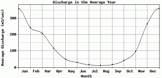
| Avg | 359.75 | 243.13 | 208.88 | 116.88 | 49.5 | 29.81 | 15.38 | 10.68 | 15.75 | 40.79 | 96.79 | 265.71 | 117.32 |
| |
|
|
|
|
|
|
|
|
|
|
|
|
|
| Std Dev | 89.31 |
55.49 |
92.54 |
33.76 |
7.72 |
15.65 |
3.9 |
5.18 |
8.93 |
21.49 |
38.07 |
83.32 |
18.95 |
| |
|
|
|
|
|
|
|
|
|
|
|
|
|
| | Jan | Feb | Mar | Apr | May | Jun | Jul | Aug | Sep | Oct | Nov | Dec | Avg Annual |
Click here for this table in tab-delimited format.
Tab-delimited format will open in most table browsing software, i.e. Excel, etc.
View this station on the map.
Return to start.