Results
| Country: | Canada
| | Station: | UpperMuskrat Falls | | River: | Churchill | | Area: | 92500 km2 | | Lat: | 53.26 | | Lon: | -60.75 | | Source: | RivDIS | | PointID: | 326 | | Area Units: | km2 | | Discharge Units: | m3/sec | | Starting Year: | 1966 | | Ending Year: | 1984 | | Total Years: | 19 | | Total Usable Years: | 19 | |
| |
| Year | Jan | Feb | Mar | Apr | May | Jun | Jul | Aug | Sep | Oct | Nov | Dec | Avg Annual |
|---|
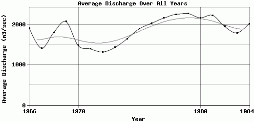
| 1966 | 617 | 532 | 484 | 462 | 816 | 4300 | 5320 | 3000 | 1910 | 2050 | 2250 | 1240 | 1915.08 |
| 1967 | 841 | 616 | 518 | 453 | 1520 | 3480 | 2480 | 1900 | 1170 | 1230 | 1630 | 1150 | 1415.67 |
| 1968 | 744 | 662 | 619 | 701 | 2790 | 4350 | 2340 | 1720 | 2280 | 2420 | 1910 | 1160 | 1808 |
| 1969 | 901 | 805 | 760 | 781 | 1890 | 5070 | 4300 | 2530 | 1980 | 2330 | 2070 | 1550 | 2080.58 |
| 1970 | 1020 | 883 | 805 | 789 | 1210 | 3910 | 3480 | 1850 | 1280 | 1110 | 907 | 593 | 1486.42 |
| 1971 | 532 | 498 | 484 | 609 | 2860 | 4130 | 2340 | 1120 | 982 | 1340 | 1000 | 909 | 1400.33 |
| 1972 | 742 | 764 | 776 | 773 | 994 | 4300 | 1590 | 1170 | 1060 | 1590 | 1040 | 1100 | 1324.92 |
| 1973 | 1540 | 1710 | 1020 | 960 | 2650 | 1820 | 1430 | 1100 | 1130 | 1280 | 1280 | 1320 | 1436.67 |
| 1974 | 1240 | 1325 | 1262 | 1789 | 2098 | 3624 | 1679 | 1279 | 1288 | 1520 | 1328 | 1407 | 1653.25 |
| 1975 | 1340 | 1340 | 1290 | 1280 | 2100 | 4070 | 2320 | 2560 | 1740 | 1620 | 1610 | 1520 | 1899.17 |
| 1976 | 1600 | 1620 | 1480 | 1650 | 3200 | 2510 | 1880 | 2310 | 2720 | 2310 | 1600 | 1580 | 2038.33 |
| 1977 | 1670 | 1530 | 1460 | 2130 | 2850 | 4220 | 1570 | 1890 | 2100 | 2530 | 2010 | 2030 | 2165.83 |
| 1978 | 2050 | 2070 | 1970 | 1810 | 2880 | 3590 | 2060 | 2490 | 2110 | 2260 | 1840 | 1990 | 2260 |
| 1979 | 2020 | 2070 | 2030 | 2060 | 3600 | 1980 | 2790 | 2830 | 1840 | 2080 | 2230 | 1840 | 2280.83 |
| 1980 | 1780 | 1840 | 1850 | 1810 | 3530 | 2960 | 2730 | 1950 | 1720 | 1960 | 1990 | 1980 | 2175 |
| 1981 | 2040 | 2050 | 1890 | 1640 | 2800 | 3240 | 3020 | 2320 | 1650 | 2070 | 2060 | 2070 | 2237.5 |
| 1982 | 1980 | 1970 | 1980 | 1820 | 2400 | 3530 | 1990 | 1700 | 1730 | 1340 | 1500 | 1580 | 1960 |
| 1983 | 1610 | 1590 | 1520 | 1710 | 3060 | 1920 | 1640 | 1440 | 1550 | 1850 | 1800 | 1910 | 1800 |
| 1984 | 1940 | 1850 | 1810 | 1630 | 3360 | 2850 | 1890 | 1620 | 1880 | 1820 | 1840 | 1840 | 2027.5 |
| |
|
|
|
|
|
|
|
|
|
|
|
|
|
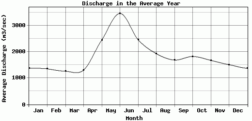
| Avg | 1379.32 | 1353.95 | 1263.58 | 1308.26 | 2453.05 | 3466 | 2465.74 | 1935.74 | 1690.53 | 1826.84 | 1678.68 | 1514.16 | 1861.32 |
| |
|
|
|
|
|
|
|
|
|
|
|
|
|
| Std Dev | 519.22 |
560.07 |
549.37 |
561.49 |
820.7 |
896.47 |
975.59 |
567.09 |
446.19 |
432.13 |
400.46 |
408.22 |
312.74 |
| |
|
|
|
|
|
|
|
|
|
|
|
|
|
| | Jan | Feb | Mar | Apr | May | Jun | Jul | Aug | Sep | Oct | Nov | Dec | Avg Annual |
Click here for this table in tab-delimited format.
Tab-delimited format will open in most table browsing software, i.e. Excel, etc.
View this station on the map.
Return to start.