Results
| Country: | U.S.A.
| | Station: | TOPOCK, AZ. | | River: | COLORADO RIVER | | Area: | 38925654.32 | | Lat: | 34.69 | | Lon: | -114.46 | | Source: | USGS | | PointID: | 9424000 | | Area Units: | km2 | | Discharge Units: | m3/sec | | Starting Year: | 1905 | | Ending Year: | 1907 | | Total Years: | 3 | | Total Usable Years: | 3 | |
| |
| Year | Jan | Feb | Mar | Apr | May | Jun | Jul | Aug | Sep | Oct | Nov | Dec | Avg Annual |
|---|
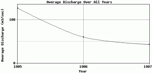
| 1905 | 45.63 | 232.56 | 433.18 | 355.6 | 130.43 | 39.8 | 14.99 | 16.98 | 20.46 | 9.69 | 181.07 | 47.7 | 127.34 |
| 1906 | 41.73 | 40.54 | 220.03 | 143.93 | 47.96 | 18.88 | 14.54 | 24.6 | 13.19 | 8.49 | 7.79 | 140.24 | 60.16 |
| 1907 | 92.29 | 72.19 | 105.04 | 54.87 | 21.18 | 14.56 | 12.11 | 36.81 | 32.03 | 37.44 | 24.91 | 13.2 | 43.05 |
| |
|
|
|
|
|
|
|
|
|
|
|
|
|
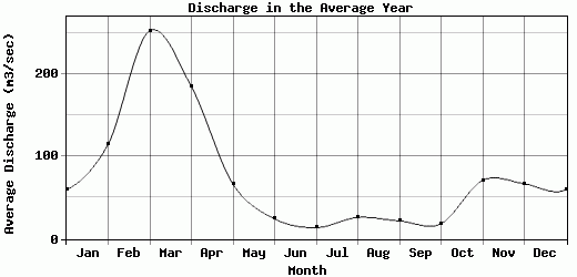
| Avg | 59.88 | 115.1 | 252.75 | 184.8 | 66.52 | 24.41 | 13.88 | 26.13 | 21.89 | 18.54 | 71.26 | 67.05 | 76.85 |
| |
|
|
|
|
|
|
|
|
|
|
|
|
|
| Std Dev | 22.97 |
84.06 |
135.95 |
126.13 |
46.49 |
11.02 |
1.26 |
8.17 |
7.76 |
13.37 |
77.96 |
53.64 |
36.38 |
| |
|
|
|
|
|
|
|
|
|
|
|
|
|
| | Jan | Feb | Mar | Apr | May | Jun | Jul | Aug | Sep | Oct | Nov | Dec | Avg Annual |
Click here for this table in tab-delimited format.
Tab-delimited format will open in most table browsing software, i.e. Excel, etc.
View this station on the map.
Return to start.