Results
| Country: | U.S.A.
| | Station: | ROCK ISLAND DAM, WA | | River: | COLUMBIA RIVER | | Area: | 231532.28 | | Lat: | 47.33 | | Lon: | -120.07 | | Source: | USGS | | PointID: | 12462600 | | Area Units: | km2 | | Discharge Units: | m3/sec | | Starting Year: | 1913 | | Ending Year: | 1919 | | Total Years: | 7 | | Total Usable Years: | 2 | |
| |
| Year | Jan | Feb | Mar | Apr | May | Jun | Jul | Aug | Sep | Oct | Nov | Dec | Avg Annual |
|---|
| 1913 | -9999 | -9999 | -9999 | -9999 | -9999 | -9999 | -9999 | -9999 | -9999 | -9999 | -9999 | -9999 | -9999 |
| 1914 | -9999 | -9999 | -9999 | -9999 | -9999 | -9999 | -9999 | -9999 | -9999 | -9999 | -9999 | -9999 | -9999 |
| 1915 | -9999 | -9999 | -9999 | -9999 | -9999 | -9999 | -9999 | -9999 | -9999 | -9999 | -9999 | -9999 | -9999 |
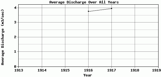
| 1916 | 1.71 | 1.44 | 1.91 | 10.28 | 8.42 | 6.4 | 4.34 | 3.54 | 3.53 | 0.74 | 1.15 | 1.6 | 3.76 |
| 1917 | 1.26 | 2.15 | 2.4 | 2.28 | 8.63 | 6.56 | 7.41 | 5.41 | 5.06 | 2.01 | 2.09 | 2.32 | 3.96 |
| 1918 | -9999 | -9999 | -9999 | -9999 | -9999 | -9999 | -9999 | -9999 | -9999 | -9999 | -9999 | -9999 | -9999 |
| 1919 | -9999 | -9999 | -9999 | -9999 | -9999 | -9999 | -9999 | -9999 | -9999 | -9999 | -9999 | -9999 | -9999 |
| |
|
|
|
|
|
|
|
|
|
|
|
|
|
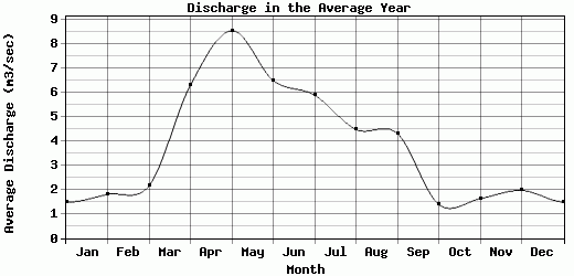
| Avg | 1.49 | 1.8 | 2.15 | 6.28 | 8.53 | 6.48 | 5.88 | 4.47 | 4.3 | 1.38 | 1.62 | 1.96 | 3.86 |
| |
|
|
|
|
|
|
|
|
|
|
|
|
|
| Std Dev | 0.23 |
0.36 |
0.25 |
4 |
0.11 |
0.08 |
1.54 |
0.94 |
0.77 |
0.64 |
0.47 |
0.36 |
0.1 |
| |
|
|
|
|
|
|
|
|
|
|
|
|
|
| | Jan | Feb | Mar | Apr | May | Jun | Jul | Aug | Sep | Oct | Nov | Dec | Avg Annual |
Click here for this table in tab-delimited format.
Tab-delimited format will open in most table browsing software, i.e. Excel, etc.
View this station on the map.
Return to start.