Results
| Country: | U.S.A.
| | Station: | MCNARY DAM,NEAR UMATILLA,OREG. | | River: | COLUMBIA RIVER | | Area: | 554227.15 | | Lat: | 45.93 | | Lon: | -119.29 | | Source: | USGS | | PointID: | 14019200 | | Area Units: | km2 | | Discharge Units: | m3/sec | | Starting Year: | 1978 | | Ending Year: | 1986 | | Total Years: | 9 | | Total Usable Years: | 8 | |
| |
| Year | Jan | Feb | Mar | Apr | May | Jun | Jul | Aug | Sep | Oct | Nov | Dec | Avg Annual |
|---|
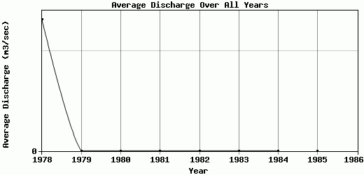
| 1978 | 0.07 | 0.13 | 0.11 | 0.05 | 1.78 | 5.77 | 0 | 0 | 0 | 0 | 0 | 0 | 0.66 |
| 1979 | 0 | 0 | 0 | 0 | 0.01 | 0 | 0.02 | 0 | 0 | 0 | 0 | 0 | 0 |
| 1980 | 0 | 0 | 0 | 0 | 0 | 0.01 | 0.01 | 0 | 0 | 0 | 0 | 0 | 0 |
| 1981 | 0 | 0 | 0 | 0 | 0 | 0 | 0.01 | 0 | 0 | 0 | 0.01 | 0.01 | 0 |
| 1982 | 0.01 | 0 | 0.01 | 0.01 | 0.01 | 0 | 0 | 0 | 0 | 0 | 0 | 0 | 0 |
| 1983 | 0 | 0 | 0 | 0 | 0 | 0 | 0 | 0 | 0 | 0 | 0 | 0 | 0 |
| 1984 | 0 | 0 | 0 | 0 | 0 | 0 | 0 | 0 | 0 | 0 | 0 | 0 | 0 |
| 1985 | 0 | 0 | 0 | 0 | 0 | 0 | 0 | 0 | 0 | 0 | 0 | 0 | 0 |
| 1986 | -9999 | -9999 | -9999 | -9999 | -9999 | -9999 | -9999 | -9999 | -9999 | -9999 | -9999 | -9999 | -9999 |
| |
|
|
|
|
|
|
|
|
|
|
|
|
|
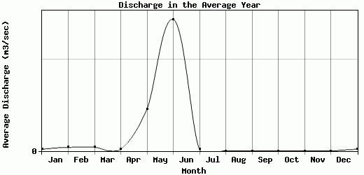
| Avg | 0.01 | 0.02 | 0.02 | 0.01 | 0.23 | 0.72 | 0.01 | 0 | 0 | 0 | 0 | 0 | 0.08 |
| |
|
|
|
|
|
|
|
|
|
|
|
|
|
| Std Dev | 0.02 |
0.04 |
0.04 |
0.02 |
0.59 |
1.91 |
0.01 |
0 |
0 |
0 |
0 |
0 |
0.22 |
| |
|
|
|
|
|
|
|
|
|
|
|
|
|
| | Jan | Feb | Mar | Apr | May | Jun | Jul | Aug | Sep | Oct | Nov | Dec | Avg Annual |
Click here for this table in tab-delimited format.
Tab-delimited format will open in most table browsing software, i.e. Excel, etc.
View this station on the map.
Return to start.