Results
| Country: | Surinam
| | Station: | Maksita | | River: | Coppename | | Area: | 12300 km2 | | Lat: | 4.9 | | Lon: | -56.12 | | Source: | RivDIS | | PointID: | 1117 | | Area Units: | km2 | | Discharge Units: | m3/sec | | Starting Year: | 1973 | | Ending Year: | 1979 | | Total Years: | 7 | | Total Usable Years: | 7 | |
| |
| Year | Jan | Feb | Mar | Apr | May | Jun | Jul | Aug | Sep | Oct | Nov | Dec | Avg Annual |
|---|
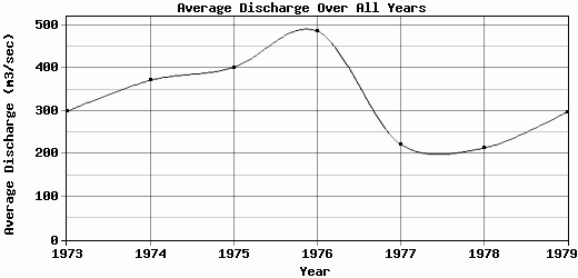
| 1973 | 67 | 75 | 132 | 216 | 489 | 851 | 449 | 331 | 371 | 196 | 115 | 289 | 298.42 |
| 1974 | 388 | 358 | 184 | 250 | 174 | 803 | 1060 | 618 | 285 | 129 | 79 | 123 | 370.92 |
| 1975 | 248 | 153 | 194 | 308 | 522 | 953 | 799 | 784 | 499 | 135 | 144 | 73 | 401 |
| 1976 | 331 | 324 | 472 | 1010 | 1420 | 1030 | 764 | 291 | 112 | 39 | 15.5 | 27.5 | 486.33 |
| 1977 | 85.5 | 108 | 165 | 279 | 419 | 390 | 567 | 334 | 108 | 63.5 | 19.5 | 138 | 223.04 |
| 1978 | 89 | 185 | 134 | 245 | 382 | 492 | 357 | 377 | 150 | 56.5 | 26 | 65 | 213.21 |
| 1979 | 108 | 83.5 | 139 | 560 | 506 | 927 | 540 | 355 | 118 | 77 | 29 | 130 | 297.71 |
| |
|
|
|
|
|
|
|
|
|
|
|
|
|
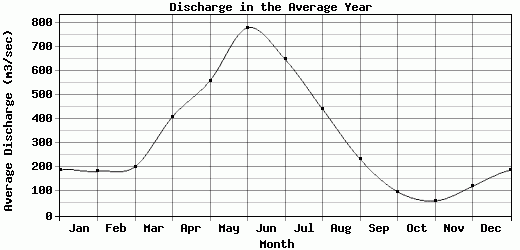
| Avg | 188.07 | 183.79 | 202.86 | 409.71 | 558.86 | 778 | 648 | 441.43 | 234.71 | 99.43 | 61.14 | 120.79 | 327.23 |
| |
|
|
|
|
|
|
|
|
|
|
|
|
|
| Std Dev | 122.71 |
105.96 |
112.21 |
267.4 |
368.31 |
225.08 |
223.13 |
171.76 |
142.86 |
51.76 |
48.06 |
78.18 |
91.2 |
| |
|
|
|
|
|
|
|
|
|
|
|
|
|
| | Jan | Feb | Mar | Apr | May | Jun | Jul | Aug | Sep | Oct | Nov | Dec | Avg Annual |
Click here for this table in tab-delimited format.
Tab-delimited format will open in most table browsing software, i.e. Excel, etc.
View this station on the map.
Return to start.