Results
| Country: | Mexico
| | Station: | LasPerlas | | River: | Cortzacoalcos | | Area: | 9224 km2 | | Lat: | 17.63 | | Lon: | -94.87 | | Source: | RivDIS | | PointID: | 1080 | | Area Units: | km2 | | Discharge Units: | m3/sec | | Starting Year: | 1976 | | Ending Year: | 1979 | | Total Years: | 4 | | Total Usable Years: | 4 | |
| |
| Year | Jan | Feb | Mar | Apr | May | Jun | Jul | Aug | Sep | Oct | Nov | Dec | Avg Annual |
|---|
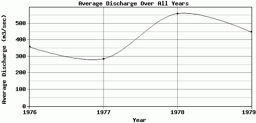
| 1976 | 295 | 191 | 121 | 76 | 62.5 | 185 | 401 | 705 | 1201 | 422 | 349 | 293 | 358.46 |
| 1977 | 199 | 162 | 115 | 85 | 54.5 | 107 | 385 | 691 | 456 | 403 | 447 | 331 | 286.29 |
| 1978 | 187 | 162 | 109 | 71 | 84.5 | 505 | 1178 | 822 | 1558 | 1220 | 441 | 377 | 559.54 |
| 1979 | 256 | 186 | 131 | 89 | 85.5 | 235 | 433 | 1543 | 1304 | 395 | 299 | 427 | 448.63 |
| |
|
|
|
|
|
|
|
|
|
|
|
|
|
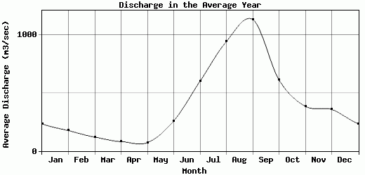
| Avg | 234.25 | 175.25 | 119 | 80.25 | 71.75 | 258 | 599.25 | 940.25 | 1129.75 | 610 | 384 | 357 | 413.23 |
| |
|
|
|
|
|
|
|
|
|
|
|
|
|
| Std Dev | 43.7 |
13.37 |
8.12 |
7.12 |
13.55 |
149.72 |
334.59 |
351.7 |
410.11 |
352.32 |
62.59 |
50.18 |
102.19 |
| |
|
|
|
|
|
|
|
|
|
|
|
|
|
| | Jan | Feb | Mar | Apr | May | Jun | Jul | Aug | Sep | Oct | Nov | Dec | Avg Annual |
Click here for this table in tab-delimited format.
Tab-delimited format will open in most table browsing software, i.e. Excel, etc.
View this station on the map.
Return to start.