Results
| Country: | U.S.A.
| | Station: | RACCOON R AT DES MOINES, | | River: | DES MOINES RIVER | | Area: | 25585.09 | | Lat: | 41.57 | | Lon: | -93.59 | | Source: | USGS | | PointID: | 5485500 | | Area Units: | km2 | | Discharge Units: | m3/sec | | Starting Year: | 1969 | | Ending Year: | 1982 | | Total Years: | 14 | | Total Usable Years: | 8 | |
| |
| Year | Jan | Feb | Mar | Apr | May | Jun | Jul | Aug | Sep | Oct | Nov | Dec | Avg Annual |
|---|
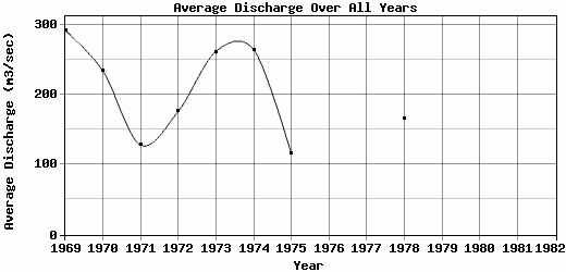
| 1969 | 135.35 | 313.92 | 310.6 | 158.3 | 198.55 | 183.51 | 118.96 | 201.09 | 305.04 | 569.59 | 554.54 | 459.35 | 292.4 |
| 1970 | 409.43 | 510.01 | 397.06 | 354.35 | 130.39 | 154.75 | 180.55 | 194.06 | 102.39 | 90.99 | 175.89 | 111.06 | 234.24 |
| 1971 | 157.04 | 169.3 | 87.83 | 146.65 | 65.29 | 92.42 | 146.15 | 119.69 | 29.97 | 129.18 | 179.44 | 217.43 | 128.37 |
| 1972 | 179.73 | 207.76 | 179.45 | 179.06 | 46.32 | 216.03 | 188.77 | 132.82 | 219.67 | 125.17 | 195.3 | 244.96 | 176.25 |
| 1973 | 251.4 | 243.66 | 222.84 | 286.94 | 128.35 | 150.3 | 239.75 | 288.84 | 367.41 | 311.77 | 312.17 | 340.4 | 261.99 |
| 1974 | 286.39 | 149.1 | 191.63 | 144.48 | 121.56 | 192.19 | 523.52 | 556.2 | 465.79 | 254.92 | 155.38 | 135.68 | 264.74 |
| 1975 | 116.75 | 76.39 | 72.39 | 46.71 | 15.75 | 54.66 | 175.3 | 166.44 | 161.44 | 157.02 | 226.05 | 115.98 | 115.41 |
| 1976 | -9999 | -9999 | -9999 | -9999 | -9999 | -9999 | -9999 | -9999 | -9999 | -9999 | -9999 | -9999 | -9999 |
| 1977 | -9999 | -9999 | -9999 | -9999 | -9999 | -9999 | -9999 | -9999 | -9999 | -9999 | -9999 | -9999 | -9999 |
| 1978 | 207.8 | 160.96 | 278.71 | 165.01 | 95.76 | 120.48 | 183.28 | 261.65 | 178.02 | 125.94 | 131.56 | 80.38 | 165.8 |
| 1979 | -9999 | -9999 | -9999 | -9999 | -9999 | -9999 | -9999 | -9999 | -9999 | -9999 | -9999 | -9999 | -9999 |
| 1980 | -9999 | -9999 | -9999 | -9999 | -9999 | -9999 | -9999 | -9999 | -9999 | -9999 | -9999 | -9999 | -9999 |
| 1981 | -9999 | -9999 | -9999 | -9999 | -9999 | -9999 | -9999 | -9999 | -9999 | -9999 | -9999 | -9999 | -9999 |
| 1982 | -9999 | -9999 | -9999 | -9999 | -9999 | -9999 | -9999 | -9999 | -9999 | -9999 | -9999 | -9999 | -9999 |
| |
|
|
|
|
|
|
|
|
|
|
|
|
|
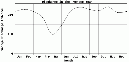
| Avg | 217.99 | 228.89 | 217.56 | 185.19 | 100.25 | 145.54 | 219.53 | 240.1 | 228.72 | 220.57 | 241.29 | 213.16 | 204.9 |
| |
|
|
|
|
|
|
|
|
|
|
|
|
|
| Std Dev | 90 |
124.86 |
102.88 |
88.36 |
53.74 |
50.5 |
119.4 |
131.26 |
134.12 |
149.39 |
128.95 |
123.15 |
62.82 |
| |
|
|
|
|
|
|
|
|
|
|
|
|
|
| | Jan | Feb | Mar | Apr | May | Jun | Jul | Aug | Sep | Oct | Nov | Dec | Avg Annual |
Click here for this table in tab-delimited format.
Tab-delimited format will open in most table browsing software, i.e. Excel, etc.
View this station on the map.
Return to start.