Results
| Country: | U.S.A.
| | Station: | MURPHY ID | | River: | SNAKE RIVER | | Area: | 108514.57 | | Lat: | 43.29 | | Lon: | -116.42 | | Source: | USGS | | PointID: | 13172500 | | Area Units: | km2 | | Discharge Units: | m3/sec | | Starting Year: | 1986 | | Ending Year: | 1993 | | Total Years: | 8 | | Total Usable Years: | 7 | |
| |
| Year | Jan | Feb | Mar | Apr | May | Jun | Jul | Aug | Sep | Oct | Nov | Dec | Avg Annual |
|---|
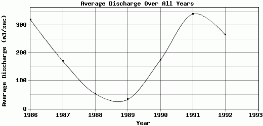
| 1986 | 41.38 | 70.19 | 427.18 | 458.92 | 566.71 | 414.37 | 495.18 | 207.12 | 168 | 510.8 | 312.5 | 176.14 | 320.71 |
| 1987 | 88.05 | 69.74 | 160.8 | 397.83 | 223.8 | 175.78 | 242.57 | 252.51 | 181.85 | 71.45 | 70.27 | 121.83 | 171.37 |
| 1988 | 57.64 | 88.37 | 110.3 | 106.97 | 119.83 | 50.31 | 23.79 | 15.13 | 14.34 | 19.91 | 17.95 | 17.26 | 53.48 |
| 1989 | 18.93 | 17.15 | 51.13 | 32.58 | 67.16 | 57.84 | 37.88 | 19.95 | 49.23 | 17.58 | 14.83 | 13.4 | 33.14 |
| 1990 | 12.75 | 14.15 | 171.42 | 69.46 | 319.88 | 706.48 | 410.28 | 245.3 | 71.75 | 24.78 | 24.02 | 28.45 | 174.89 |
| 1991 | 15.49 | 55.53 | 426.21 | 685.18 | 787.94 | 1147.78 | 331.49 | 179.29 | 35.37 | 29.28 | 111.76 | 283.18 | 340.71 |
| 1992 | 176.62 | 231.91 | 427.44 | 420.91 | 278.57 | 183.96 | 315.54 | 207.36 | 171.41 | 139.69 | 358.44 | 282.27 | 266.18 |
| 1993 | -9999 | -9999 | -9999 | -9999 | -9999 | -9999 | -9999 | -9999 | -9999 | -9999 | -9999 | -9999 | -9999 |
| |
|
|
|
|
|
|
|
|
|
|
|
|
|
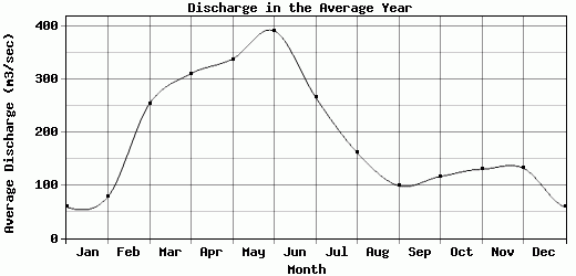
| Avg | 58.69 | 78.15 | 253.5 | 310.26 | 337.7 | 390.93 | 265.25 | 160.95 | 98.85 | 116.21 | 129.97 | 131.79 | 194.35 |
| |
|
|
|
|
|
|
|
|
|
|
|
|
|
| Std Dev | 54.28 |
67.83 |
154.48 |
226.46 |
236.83 |
375.89 |
165.33 |
93.55 |
66.87 |
166.12 |
134.4 |
110.48 |
112.94 |
| |
|
|
|
|
|
|
|
|
|
|
|
|
|
| | Jan | Feb | Mar | Apr | May | Jun | Jul | Aug | Sep | Oct | Nov | Dec | Avg Annual |
Click here for this table in tab-delimited format.
Tab-delimited format will open in most table browsing software, i.e. Excel, etc.
View this station on the map.
Return to start.