Results
| Country: | Mali
| | Station: | Gourbassi | | River: | Faleme | | Area: | 15000 km2 | | Lat: | 13.23 | | Lon: | -11.38 | | Source: | RivDIS | | PointID: | 1512 | | Area Units: | km2 | | Discharge Units: | m3/sec | | Starting Year: | 1954 | | Ending Year: | 1978 | | Total Years: | 25 | | Total Usable Years: | 22 | |
| |
| Year | Jan | Feb | Mar | Apr | May | Jun | Jul | Aug | Sep | Oct | Nov | Dec | Avg Annual |
|---|
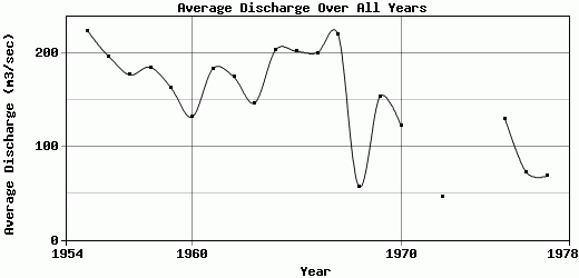
| 1954 | -9999 | -9999 | -9999 | -9999 | 1.1 | 53 | 293 | 1012 | 835 | 266 | 126 | 57 | -9999 |
| 1955 | 28 | 15.6 | 8.4 | 3.3 | 3.2 | 20.4 | 161 | 1013 | 860 | 401 | 120 | 52 | 223.83 |
| 1956 | 30 | 16 | 8.2 | 2.7 | 0.9 | 8.9 | 119 | 637 | 1079 | 327 | 91 | 41 | 196.73 |
| 1957 | 22.2 | 11.9 | 6.2 | 2.1 | 0.7 | 35 | 121 | 635 | 692 | 424 | 121 | 49 | 176.68 |
| 1958 | 24.2 | 12.3 | 6 | 2 | 3.2 | 16.8 | 134 | 869 | 616 | 327 | 138 | 70 | 184.88 |
| 1959 | 34 | 17.1 | 10.3 | 4.5 | 1.9 | 13.9 | 138 | 588 | 801 | 231 | 78 | 34 | 162.64 |
| 1960 | 18.7 | 9.9 | 4.4 | 1.8 | 0.7 | 31 | 185 | 448 | 537 | 238 | 73 | 32 | 131.63 |
| 1961 | 16.7 | 9.8 | 4.3 | 1.3 | 0.5 | 34 | 185 | 600 | 1064 | 191 | 61 | 34 | 183.47 |
| 1962 | 30 | 7.6 | 2.2 | 1 | 0.3 | 22.5 | 113 | 585 | 916 | 300 | 81 | 35 | 174.47 |
| 1963 | 15.8 | 7.9 | 3 | 0.9 | 0.5 | 0.7 | 169 | 469 | 608 | 372 | 83 | 31 | 146.73 |
| 1964 | 15.2 | 6.1 | 2.1 | 0.6 | 0.2 | 48 | 187 | 507 | 1260 | 285 | 88 | 41 | 203.35 |
| 1965 | 20 | 10 | 6 | 2.5 | 0.5 | 19.3 | 106 | 791 | 886 | 419 | 119 | 44.9 | 202.02 |
| 1966 | 25.9 | 13.6 | 6.5 | 2.9 | 2.5 | 5 | 71.2 | 408 | 712 | 960 | 146 | 52.8 | 200.53 |
| 1967 | 27.2 | 14.1 | 6.5 | 2.9 | 1.1 | 38.7 | 158 | 500 | 1107 | 591 | 133 | 56.7 | 219.68 |
| 1968 | 32 | 16 | 8 | 3 | 4.1 | 6.3 | 36.4 | 135 | 368 | 42.4 | 21.6 | 10.2 | 56.92 |
| 1969 | 10.2 | 4.4 | 1.4 | 0.3 | 0.3 | 14.7 | 134 | 425 | 580 | 483 | 144 | 44.7 | 153.5 |
| 1970 | 21.1 | 11 | 4 | 1.2 | 0.4 | 2.5 | 51.8 | 649 | 555 | 111 | 41.8 | 19.5 | 122.36 |
| 1971 | 9.8 | 4.4 | 1.5 | 0.5 | -9999 | -9999 | 79 | 726 | 594 | 143 | 40.6 | 18 | -9999 |
| 1972 | 8 | 3 | 0.9 | 0 | 0 | 7.1 | 41.4 | 206 | 185 | 64.3 | 22.8 | 12.9 | 45.95 |
| 1973 | 4.5 | 1.6 | 0.2 | 0 | -9999 | -9999 | -9999 | -9999 | -9999 | -9999 | -9999 | -9999 | -9999 |
| 1974 | -9999 | -9999 | -9999 | -9999 | -9999 | -9999 | -9999 | -9999 | -9999 | -9999 | -9999 | -9999 | -9999 |
| 1975 | 7 | 3.3 | 1.1 | 0.3 | 0 | 0 | 150 | 298 | 834 | 188 | 53.2 | 16 | 129.24 |
| 1976 | 6.7 | 2.5 | 0.8 | 0.1 | 0 | 3 | 113 | 240 | 175 | 184 | 125 | 22 | 72.68 |
| 1977 | 10.9 | 4 | 1.1 | 0.3 | 0 | 0 | 11.5 | 143 | 393 | 191 | 55.8 | 10.9 | 68.46 |
| 1978 | 4.1 | 1.1 | 0.3 | 0 | 0 | 0 | 28.3 | 501 | -9999 | 262 | 63.2 | 2.5 | -9999 |
| |
|
|
|
|
|
|
|
|
|
|
|
|
|
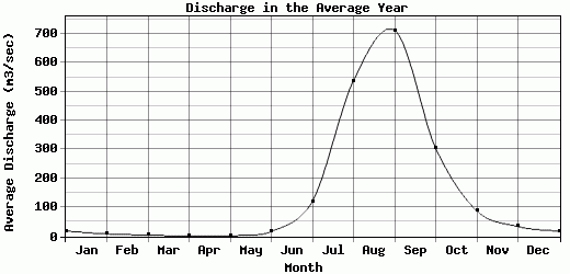
| Avg | 18.36 | 8.83 | 4.06 | 1.49 | 1 | 17.31 | 121.11 | 538.48 | 711.68 | 304.38 | 88.09 | 34.22 | 152.79 |
| |
|
|
|
|
|
|
|
|
|
|
|
|
|
| Std Dev | 9.26 |
5.05 |
2.98 |
1.27 |
1.17 |
15.89 |
63.36 |
239.62 |
281.22 |
191.47 |
38.42 |
17.52 |
53.81 |
| |
|
|
|
|
|
|
|
|
|
|
|
|
|
| | Jan | Feb | Mar | Apr | May | Jun | Jul | Aug | Sep | Oct | Nov | Dec | Avg Annual |
Click here for this table in tab-delimited format.
Tab-delimited format will open in most table browsing software, i.e. Excel, etc.
View this station on the map.
Return to start.