Results
| Country: | India
| | Station: | Mancherial | | River: | Godavary | | Area: | 102900 km2 | | Lat: | 18.83 | | Lon: | 79.45 | | Source: | RivDIS | | PointID: | 1261 | | Area Units: | km2 | | Discharge Units: | m3/sec | | Starting Year: | 1968 | | Ending Year: | 1979 | | Total Years: | 12 | | Total Usable Years: | 11 | |
| |
| Year | Jan | Feb | Mar | Apr | May | Jun | Jul | Aug | Sep | Oct | Nov | Dec | Avg Annual |
|---|
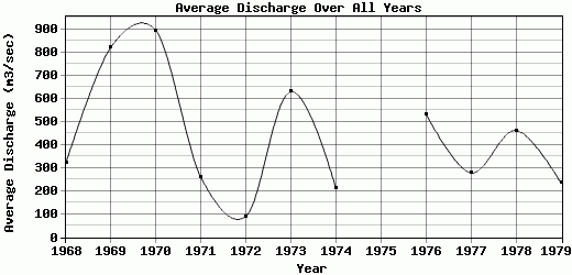
| 1968 | 82 | 37 | 136 | 14 | 10 | 13 | 609 | 1212 | 600 | 907 | 169 | 66 | 321.25 |
| 1969 | 49 | 35 | 43 | 50 | 46 | 18 | 917 | 1528 | 6542 | 364 | 213 | 72 | 823.08 |
| 1970 | 49 | 31 | 25 | 10 | 9 | 427 | 469 | 5477 | 3260 | 704 | 174 | 97 | 894.33 |
| 1971 | 48 | 33 | 23 | 16 | 34 | 14 | 113 | 751 | 716 | 1185 | 133 | 42 | 259 |
| 1972 | 34 | 21 | 17 | 8 | 3 | 51 | 400 | 248 | 244 | 23 | 26 | 12 | 90.58 |
| 1973 | 4 | 3 | 2 | 1 | 1 | 31 | 705 | 2991 | 1248 | 2016 | 442 | 114 | 629.83 |
| 1974 | 71 | 57 | 33 | 33 | 45 | 55 | 61 | 374 | 215 | 1239 | 249 | 87 | 209.92 |
| 1975 | -9999 | -9999 | -9999 | -9999 | -9999 | -9999 | -9999 | -9999 | -9999 | -9999 | -9999 | -9999 | -9999 |
| 1976 | 86 | 48 | 38 | 17 | 7 | 67 | 1736 | 2460 | 1704 | 121 | 65 | 61 | 534.17 |
| 1977 | 33 | 28 | 19 | 7 | 8 | 17 | 646 | 754 | 1322 | 195 | 69 | 241 | 278.25 |
| 1978 | 56 | 53 | 25 | 12 | 10 | 315 | 2175 | 1772 | 539 | 379 | 170 | 41 | 462.25 |
| 1979 | 66 | 52 | 54 | 18 | 22 | 58 | 65 | 1002 | 740 | 519 | 83 | 142 | 235.08 |
| |
|
|
|
|
|
|
|
|
|
|
|
|
|
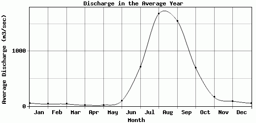
| Avg | 52.55 | 36.18 | 37.73 | 16.91 | 17.73 | 96.91 | 717.82 | 1688.09 | 1557.27 | 695.64 | 163 | 88.64 | 430.7 |
| |
|
|
|
|
|
|
|
|
|
|
|
|
|
| Std Dev | 22.66 |
15.21 |
33.8 |
13.03 |
15.75 |
132.69 |
646.9 |
1443.82 |
1778.01 |
571.88 |
109.73 |
59.27 |
250.03 |
| |
|
|
|
|
|
|
|
|
|
|
|
|
|
| | Jan | Feb | Mar | Apr | May | Jun | Jul | Aug | Sep | Oct | Nov | Dec | Avg Annual |
Click here for this table in tab-delimited format.
Tab-delimited format will open in most table browsing software, i.e. Excel, etc.
View this station on the map.
Return to start.