Results
| Country: | U.S.A.
| | Station: | Sand Springs nr Tulsa, OK | | River: | Arkansas River | | Area: | 193241.40 | | Lat: | 36.11 | | Lon: | -96.11 | | Source: | USGS | | PointID: | 7164400 | | Area Units: | km2 | | Discharge Units: | m3/sec | | Starting Year: | 1970 | | Ending Year: | 1972 | | Total Years: | 3 | | Total Usable Years: | 2 | |
| |
| Year | Jan | Feb | Mar | Apr | May | Jun | Jul | Aug | Sep | Oct | Nov | Dec | Avg Annual |
|---|
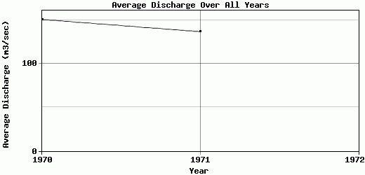
| 1970 | 87.94 | 64.83 | 45.67 | 564.77 | 316.23 | 230.09 | 146.08 | 42.04 | 44.94 | 115.79 | 85.8 | 61.14 | 150.44 |
| 1971 | 63.33 | 76.31 | 125.53 | 65.61 | 81.95 | 195.26 | 105.93 | 95.67 | 219.88 | 176.93 | 147.99 | 283.72 | 136.51 |
| 1972 | -9999 | -9999 | -9999 | -9999 | -9999 | -9999 | -9999 | -9999 | -9999 | -9999 | -9999 | -9999 | -9999 |
| |
|
|
|
|
|
|
|
|
|
|
|
|
|
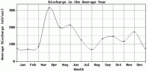
| Avg | 75.63 | 70.57 | 85.6 | 315.19 | 199.09 | 212.68 | 126.01 | 68.86 | 132.41 | 146.36 | 116.9 | 172.43 | 143.48 |
| |
|
|
|
|
|
|
|
|
|
|
|
|
|
| Std Dev | 12.31 |
5.74 |
39.93 |
249.58 |
117.14 |
17.42 |
20.08 |
26.82 |
87.47 |
30.57 |
31.1 |
111.29 |
6.97 |
| |
|
|
|
|
|
|
|
|
|
|
|
|
|
| | Jan | Feb | Mar | Apr | May | Jun | Jul | Aug | Sep | Oct | Nov | Dec | Avg Annual |
Click here for this table in tab-delimited format.
Tab-delimited format will open in most table browsing software, i.e. Excel, etc.
View this station on the map.
Return to start.